Warning: Undefined variable $prli_blogurl in /home/nowdiscoverit/public_html/wp-content/plugins/pretty-link/pro/pretty-link-pro.php on line 79
Geography Archives - Page 2 of 4 - NowDiscoverIt
Home » Geography » Page 2
Category:

Geography

The Berlin Wall stands as a powerful symbol of the tensions and divisions that defined the Cold War era. This physical barrier, erected in the heart of Berlin, not only divided a city but also represented the larger ideological divide between the East and West.

In this article, we will delve into the historical context and impact of the Berlin Wall, exploring its construction, life on both sides, international reactions, and eventual fall.

As we uncover the story of the Berlin Wall, we also uncover the story of the Cold War and its lasting effects on the world. Join us as we journey through this pivotal moment in history and understand the significance of the Berlin Wall in shaping our world today.

The Construction of the Berlin Wall

The division of Germany after World War II had left the country in a state of political and economic turmoil. The Soviet Union, which controlled the eastern part of Germany, implemented strict communist policies that were in stark contrast to the democratic ideologies of the Western powers. This ideological divide, coupled with the economic disparity between East and West Germany, led to a rise in tensions between the Soviet Union and the United States and its allies.

In the early 1960s, the situation reached a boiling point as thousands of East Germans began to flee to the West in search of better opportunities and freedom. This mass exodus was a major embarrassment for the Soviet Union, which was losing its skilled workforce and intellectuals.

In response, on August 13, 1961, the East German government, with the support of the Soviet Union, began the construction of the Berlin Wall. This physical barrier was meant to prevent East Germans from crossing over to the West, effectively dividing the city of Berlin into two separate entities. The Wall was made up of concrete segments, barbed wire, and guard towers, stretching over 155 kilometers.

The primary purpose of the Berlin Wall was to stop the flow of people from East to West. East Germans were not allowed to leave the country without proper authorization, and those who attempted to flee faced harsh consequences. The border was heavily guarded, with soldiers instructed to shoot anyone who attempted to escape. Despite these measures, many East Germans tried to cross the Wall, often risking their lives in the process. According to estimates, over 5,000 people attempted to escape, and at least 140 were killed while trying to do so.

The construction of the Berlin Wall not only physically divided families and friends but also created a stark contrast between life in the East and the West. West Berlin, with its democratic government and capitalist economy, flourished and became a symbol of freedom and prosperity. Meanwhile, East Berlin, under the strict control of the Soviet Union, suffered from economic hardships and lack of basic freedoms.

The East German government used propaganda to portray life in the East as superior to the West. But in reality, many East Germans longed for the freedoms and opportunities that the West offered. This stark contrast between the two sides of the Wall only intensified the tensions and highlighted the failure of communism.

The construction of the Berlin Wall was met with widespread condemnation from the international community, particularly from the United States and its allies. The Western powers saw it as a violation of basic human rights and a symbol of oppression and tyranny. In response, they imposed sanctions and restrictions on the Soviet Union, further escalating the Cold War.

The construction of the Berlin Wall was a major turning point in the Cold War and had a profound impact on the world at large. It not only physically divided a city but also symbolized the larger divide between the East and the West. It intensified the fear of a potential nuclear war and added to the already existing tensions between the two superpowers.

However, the construction of the Berlin Wall was not the end of the story. In the late 1980s, with the collapse of the Soviet Union and the rise of peaceful protests in East Germany, the Berlin Wall eventually fell on November 9, 1989. This momentous event not only marked the reunification of Germany but also signaled the end of the Cold War and the fall of communism in Europe.

The construction of the Berlin Wall and its eventual fall left a lasting impact on the lives of millions of people. It serves as a reminder of the atrocities of authoritarian regimes and the resilience of those fighting for freedom. The Berlin Wall has become a powerful symbol of the human desire for liberty and serves as a reminder to never take our freedom for granted.


Life on Both Sides of the Wall

The Berlin Wall was not just a physical barrier that divided the city of Berlin, but it also created a stark contrast between the two sides – East and West. The Wall was not just a symbol of political division, but it also had a profound impact on the lives of the people living in East and West Berlin.

On the Western side of the Wall, life was relatively prosperous and free. West Berlin was part of the Federal Republic of Germany, a democratic and capitalist country. The economy was thriving, and people enjoyed freedom of speech, religion, and movement. The streets were filled with colorful buildings, luxurious cars, and bustling cafes. It was a stark contrast to the monotony and strict control under Communist rule in the East.

On the Eastern side of the Wall, life was completely different. East Berlin was part of the German Democratic Republic, a socialist and authoritarian state controlled by the Soviet Union. The economy was struggling, and people faced shortages of basic necessities like food and clothing. The government controlled all aspects of life, including the media, education, and employment. Citizens lived in constant fear of surveillance and repression by the secret police.

The Wall also had a devastating impact on families and loved ones who were separated by it. Overnight, people were cut off from their relatives, friends, and partners who lived on the other side of the Wall. Families were torn apart, and many never got to see each other again. The Wall was a constant reminder of the division and the pain of being separated from loved ones.

Both sides of the Wall used propaganda to portray their way of life as superior. In the East, the government used propaganda to enforce the idea that their socialist system was far better than the capitalist system in the West. They highlighted the benefits of free healthcare and education while painting a negative picture of the West as a society riddled with poverty and inequality. In the West, the government used propaganda to show the stark differences between the two sides and to highlight the repression and lack of freedom in the East.

Despite the stark differences, there were also moments of solidarity and connection between people on both sides of the Wall. Many East Germans risked their lives to escape to the West, and some West Germans helped them by providing shelter and support. This showed that the Wall could not completely divide people and their longing for freedom and unity.

The Wall also had a significant impact on international relations. The construction of the Wall was seen as a clear sign of the intensifying Cold War tensions and the Soviet Union's control over Eastern Europe. The United States and its allies strongly opposed the Wall and saw it as a symbol of oppression and a threat to global peace. They took measures such as the Berlin Airlift and the installation of their own wall of balloons filled with anti-Soviet messages to show their solidarity with West Berlin and their opposition to the Wall.


International Reactions to the Berlin Wall

The construction of the Berlin Wall in 1961 was met with shock and disbelief by the international community. This physical division of Germany was seen as a symbol of the deepening Cold War tensions between the Soviet Union and the Western powers. The United States and its allies, who had been advocating for the reunification of Germany, were outraged by the sudden and forceful separation of the city of Berlin.

The United States, in particular, strongly condemned the construction of the Berlin Wall. President John F. Kennedy declared, “A wall is a hell of a lot better than a war,” but also stated that the United States was not prepared to accept the division of Germany. In response, the United States and its allies, including France and the United Kingdom, began to increase their military presence in West Berlin as a show of support and solidarity.

The Western powers also took diplomatic measures to express their opposition to the Berlin Wall. The United States, France, and the United Kingdom issued a joint statement condemning the construction of the Wall and calling for the free movement of people and ideas. In addition, they also imposed economic sanctions on East Germany in an attempt to pressure them to tear down the Wall.

The construction of the Berlin Wall also had a significant impact on the United Nations (UN). The UN General Assembly held an emergency meeting to discuss the situation in Berlin, and many member states expressed their concern and disapproval of the Wall. However, the Soviet Union and its allies used their veto power in the United Nations Security Council to prevent any action against East Germany.

The Berlin Wall had a profound effect on the global political climate. The fear of nuclear war increased as the Berlin Wall became a visible symbol of the divided world. The United States and the Soviet Union were engaged in a constant power struggle, and the construction of the Wall further intensified this rivalry.

Despite the international opposition, the Berlin Wall continued to stand for almost three decades. However, as the Cold War began to thaw in the late 1980s, the international community's stance towards the Wall shifted. The Soviet Union's reforms and increasing pressure from the West, coupled with peaceful protests by East Germans, led to the fall of the Berlin Wall on November 9, 1989.

The fall of the Berlin Wall was met with jubilation and relief by the international community. It was seen as a monumental moment in world history, symbolizing the end of the Cold War and the reunification of Germany. The removal of the Wall also had a significant impact on global politics, as it marked the beginning of a new era of cooperation and diplomacy between the East and West.


The Fall of the Berlin Wall

After 28 years of dividing a nation and symbolizing the tense divide between two superpowers, the Berlin Wall finally fell on November 9, 1989. The fall of the Wall was a monumental event that not only changed the course of German history but also had significant implications for global politics and the Cold War. In this section, we will explore the events leading up to the fall of the Berlin Wall, its impact on the reunification of Germany, and its lasting legacy.

The Fall of the Berlin Wall was the result of years of rising tensions and mounting pressure from the people of East Germany. Since its construction in 1961, the Wall had been a symbol of oppression and separation for the citizens of Berlin. The strict border controls and harsh consequences for those who tried to escape had only intensified the desire for freedom among the people. In the late 1980s, a wave of political and economic changes known as “perestroika” and “glasnost” swept through the Soviet Union under the leadership of Mikhail Gorbachev. This led to a loosening of restrictions and an increase in political freedom, which emboldened the citizens of East Germany to demand the same.

The fall of the Berlin Wall was not a single event, but a culmination of events that took place over several months. It began with peaceful protests and demonstrations in East Berlin, demanding political reform and free elections. The government responded with force, leading to several clashes between protesters and the police. However, these protests only grew in size and intensity, with thousands of people taking to the streets every day. The pressure from the people and the changing political landscape in the Soviet Union forced the East German government to make concessions.

On the evening of November 9, 1989, an official government spokesperson announced that East German citizens would be allowed to travel freely to West Germany. This news spread like wildfire, and within hours, thousands of people flocked to the Wall, demanding to be let through. The border guards, who were not informed of this decision, were overwhelmed and eventually gave in to the pressure from the crowds. They opened the checkpoints, and people began to cross over freely, marking the end of the Berlin Wall and the beginning of a new era.

The fall of the Berlin Wall had a profound impact on German history. It paved the way for the reunification of Germany and the end of the Cold War. The two German states were officially unified on October 3, 1990, and the Wall was dismantled, symbolizing the end of division and the beginning of a new united Germany. The fall of the Wall also had significant implications for global politics, as it marked the collapse of the Soviet Union and the end of the Cold War. The United States and its allies saw this as a victory for democracy and a defeat for communism.

Today, the Berlin Wall stands as a reminder of the struggle for freedom and unity. It has become a symbol of the power of the people to bring about change and the strength of the human spirit to overcome oppression. The fall of the Wall also serves as a lesson for future generations to learn from, reminding us of the consequences of division and the importance of working towards a more united world.

The Legacy of the Berlin Wall

The fall of the Berlin Wall on November 9, 1989, marked the end of a dark chapter in world history. For 28 years, the Wall stood as a physical and symbolic divide between East and West Berlin, symbolizing the deep divide between the Soviet Union and the Western powers during the Cold War. While the Wall is no longer standing, its legacy continues to shape the world we live in today.

Firstly, the Berlin Wall serves as a reminder of the atrocities committed by authoritarian regimes. The construction of the Wall was a blatant violation of human rights, as it separated families, friends, and loved ones, and restricted the freedom of people to travel and live where they wanted. The Wall also served as a symbol of the iron grip that the communist government had on its citizens, with strict border controls and harsh consequences for those who attempted to escape. It is estimated that over 100,000 people were arrested while attempting to cross the Wall, and at least 136 people lost their lives in the process. The legacy of the Berlin Wall serves as a reminder to never take our freedoms for granted and to stand against any form of oppression.

Secondly, the fall of the Berlin Wall marked the beginning of a new era of global politics. The collapse of the Soviet Union and the reunification of Germany were significant events that paved the way for a more interconnected and interdependent world. The fall of the Wall also signaled the end of the Cold War and the beginning of a new world order. The legacy of the Berlin Wall reminds us of the power of peaceful protests and the potential for change when the people unite against injustice.

Moreover, the legacy of the Berlin Wall continues to inspire and unite people around the world in their fight for freedom and democracy. The Wall has become a symbol of hope and resilience, representing the triumph of the human spirit over oppression and division. The images of people from both sides of the Wall celebrating and embracing each other after its fall are a powerful testament to the universal desire for unity and peace. The legacy of the Berlin Wall reminds us that no wall or barrier can truly divide people who are determined to come together.

In addition, the Berlin Wall continues to be a popular tourist destination, with millions of visitors each year. It serves as a reminder of the past and a tribute to those who suffered during its existence. The remaining sections of the Wall, covered in colorful graffiti and murals, stand as a symbol of the resilience and creativity of the human spirit.

 

0 comment
0 FacebookTwitterPinterestEmail

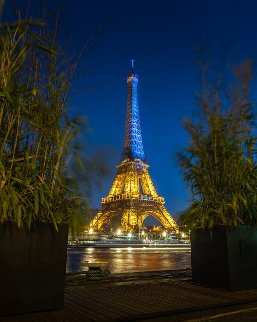
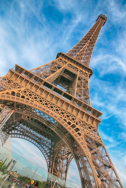
The Eiffel Tower is undeniably one of the most iconic and recognizable landmarks in the world. Located in the heart of Paris, France, it is a must-see attraction for anyone visiting the city of love.

Its towering presence and intricate design have captured the hearts of millions of visitors since its construction in 1889. In this article, we will delve into the fascinating history, architecture, and experience of visiting the Eiffel Tower.

Whether you're a first-time visitor or a frequent traveler to Paris, this article will provide you with a comprehensive guide to exploring this magnificent structure.

So, put on your walking shoes and get ready to discover the wonders of the Eiffel Tower.

History of the Eiffel Tower

The Eiffel Tower has become an iconic symbol of Paris, known and recognized all over the world. But what is the history behind this magnificent structure that draws millions of visitors each year? The Eiffel Tower was built for the 1889 World's Fair, also known as the Exposition Universelle, to celebrate the 100th anniversary of the French Revolution. It was designed by Gustave Eiffel, a renowned French engineer, and was originally intended to stand for only 20 years. Little did anyone know, it would become a permanent fixture and an integral part of Parisian culture.

However, the construction of the Eiffel Tower was met with controversy and criticism. Many Parisians deemed the tower as an eyesore and a threat to the city's aesthetic beauty. Famous artists and writers, including Guy de Maupassant and Alexandre Dumas, signed a petition against its construction. They referred to it as a “giant ungainly skeleton” and a “truly tragic street lamp.” Despite the backlash, Gustave Eiffel persevered and completed the tower in just two years, using over 18,000 iron pieces and 2.5 million rivets.

Aside from being a feat of engineering, the Eiffel Tower also holds a significant role in the identity and culture of Paris. It has become a symbol of the city and is featured in countless works of art, literature, and film. The tower has also served as a backdrop for historic events, such as the end of World War I and the annual Bastille Day celebrations. It continues to be a source of pride for the people of Paris and a must-see attraction for tourists.

The architecture and design of the Eiffel Tower are also worth noting. The tower stands at 324 meters tall, making it one of the tallest structures in the world at the time of its construction. It is composed of three levels, each offering a different perspective and experience for visitors. The intricate lattice design of the tower is not only visually striking, but also serves a functional purpose in providing stability and strength to the structure.

The materials used in the construction of the Eiffel Tower were also innovative for its time. Over 7,000 tons of iron were used, giving the tower its distinct reddish-brown color. To prevent corrosion, the iron was coated with 60 tons of paint, a process that is still repeated every seven years. The Eiffel Tower also has a unique shape, with a gradually narrowing base that widens at the top, creating an illusion of height and grandeur.

Today, visitors can experience the Eiffel Tower in various ways, including climbing the stairs or taking the elevator to the top. The first two levels offer breathtaking views of the city, while the top level features a glass floor and a champagne bar. The tower also has two restaurants, including the Michelin-starred Jules Verne, providing visitors with a one-of-a-kind dining experience.

In conclusion, the Eiffel Tower is not just a tourist attraction, but a symbol of Parisian pride and a masterpiece of engineering and design. Its history, architecture, and cultural significance make it a must-see for anyone visiting the city of love. Whether you choose to admire it from afar or brave the long lines and crowds to go up to the top, the Eiffel Tower is an experience like no other.

Architecture and Design

The Eiffel Tower is not only a symbol of Paris but also a masterpiece of architecture and design. Standing at 324 meters tall, it is an iconic landmark that has captivated visitors from all over the world for over a century. In this section, we will delve into the unique features of the Eiffel Tower and explore its design and construction.

The Eiffel Tower was designed by Gustave Eiffel, a French engineer and architect, for the 1889 World's Fair. The original plan was met with criticism and opposition from the public, who saw it as a monstrosity and an eyesore. However, Eiffel's vision prevailed, and after two years of construction, the tower was finally unveiled at the opening of the World's Fair.

The tower's design is a combination of elegance and functionality. Its structure is made up of iron lattice, which gives it a delicate appearance despite its massive size. To support its weight, over 18,000 pieces of iron were used, held together by 2.5 million rivets. The foundation of the Eiffel Tower is also a feat of engineering, with concrete and compacted gravel used to anchor the tower to the ground.

One of the most impressive features of the Eiffel Tower is its three levels, each offering a different experience for visitors. The first and second levels can be accessed by stairs or elevators, while the top level is only accessible by elevator. The observation deck on the top level provides a breathtaking 360-degree view of Paris, making it a must-visit spot for tourists.

The Eiffel Tower is also home to two restaurants, Jules Verne and 58 Tour Eiffel, both offering delicious French cuisine with an unbeatable view. For those who want to take in the sights without the hustle and bustle of the observation deck, the restaurants are a perfect option.

In addition to its striking design, the Eiffel Tower also serves as a canvas for light shows and projections, giving it a dynamic and ever-changing appearance. The tower is often lit up in different colors to mark special occasions or events, making it a popular attraction for visitors at night.

Visiting the Eiffel Tower is an experience unlike any other, and there are many ways to do so. Apart from the usual elevator ride, visitors can also choose to climb the stairs for a more adventurous journey. The stairs, located on the south pillar of the tower, offer a unique perspective of the intricate design and structure of the tower.

In conclusion, the Eiffel Tower's architecture and design are a testament to human ingenuity and engineering. Its unique structure and impressive height have made it an icon of Paris and a must-see attraction for anyone visiting the city. From its controversial beginnings to its current status as a cultural and architectural marvel, the Eiffel Tower continues to fascinate and amaze visitors from all over the world.

Experiencing the Eiffel Tower

The Eiffel Tower is not just a stunning structure to look at from a distance, it is also a must-visit attraction for anyone visiting Paris. With various ways to experience the tower, it offers a unique and unforgettable experience for people of all ages. In this section, we will explore the different ways to experience the Eiffel Tower and what makes each one special.

  1. Climbing the stairs or taking the elevator:

One of the most popular ways to experience the Eiffel Tower is by climbing the stairs or taking the elevator to the top. The tower has three levels, with the first two accessible by stairs or elevator. The third and highest level can only be reached by elevator. If you are up for a challenge, climbing the stairs can be a great option as it allows you to stop and admire the views along the way. However, if you are short on time or have any physical limitations, taking the elevator is a more convenient option.

  1. Activities and attractions:

Apart from the stunning views, there are also various activities and attractions that can be experienced at the Eiffel Tower. The tower has a light show which takes place every evening, where the tower is illuminated with thousands of sparkly lights for a few minutes. This is a must-see for anyone visiting the tower. There is also a museum on the tower's first level, where you can learn about the history and construction of the tower.

  1. Planning ahead:

Due to its immense popularity, the Eiffel Tower can get very crowded, especially during peak tourist season. To avoid long lines and disappointment, it is important to plan ahead and purchase your tickets in advance. This can be done online on the official website or through reputable tour companies. It is also recommended to visit the tower during weekdays and early in the morning to avoid the crowds.

  1. Fun Facts and Trivia:

While visiting the Eiffel Tower, it is always fun to know some interesting facts and trivia about this iconic structure. Did you know that the Eiffel Tower was originally painted red? It was painted in this color to protect it from rust, but it was later changed to its now-famous shade of brown. Another interesting fact is that the tower weighs over 10,000 tons! You can also spot the tower in various films and literature, making it a popular pop culture icon.

  1. Alternative ways to experience the tower:

If you are not keen on visiting the Eiffel Tower itself, there are still ways to experience its beauty. Taking a river cruise on the Seine is a great way to see the tower from a different perspective. You can also view the tower from various viewpoints around Paris, such as the Trocadero Gardens or the top of the Arc de Triomphe.

In conclusion, the Eiffel Tower offers a wide range of experiences for visitors to enjoy. Whether you choose to climb to the top, watch the light show, or view it from a distance, this iconic structure is a must-visit attraction in Paris. Be sure to plan ahead and take advantage of all the different ways to experience the Eiffel Tower for a truly unforgettable experience.

Fun Facts and Trivia

The Eiffel Tower is not only a symbol of Paris, but it is also a source of many interesting and lesser-known facts and trivia. Here are some fun facts that will make your visit to the Eiffel Tower even more special:

– The Eiffel Tower was originally intended to be a temporary installation for the 1889 World's Fair and was almost torn down after the event. It was saved because of its use as a communications tower.

– The tower was initially painted a reddish-brown color, but in 1907 it was repainted to its now iconic shade of brownish-gray. Today, it is repainted every seven years to protect it from rust and maintain its signature color.

– Gustave Eiffel, the tower's designer, also worked on the construction of the Statue of Liberty in New York City. The two structures share a similar design and were built around the same time.

– The Eiffel Tower weighs approximately 10,100 tons, making it one of the heaviest structures in the world. However, due to its unique design, it experiences a sway of up to 9 centimeters in strong winds.

– The Eiffel Tower has three levels open to the public. The first two levels can be reached by stairs or elevators, while the third and highest level can only be accessed by elevators.

– The observation deck on the third level offers stunning views of Paris, but did you know it also has a post office? Visitors can send postcards from the Eiffel Tower with a special postmark as a souvenir.

– You can find two restaurants on the Eiffel Tower – Le Jules Verne on the second level and 58 Tour Eiffel on the first level. Both offer a unique dining experience with magnificent views of the city.

– The Eiffel Tower has appeared in many films and TV shows, including the popular romantic comedy “Amélie” and the animated movie “Ratatouille.” It has also inspired numerous artworks and literary works.

– The tower is also a popular destination for marriage proposals, with an estimated 2,500 proposals happening each year. It is considered one of the most romantic spots in Paris.

– Every year, the Eiffel Tower hosts a spectacular light show, where 20,000 sparkling lights illuminate the tower for 5 minutes every hour after sunset. It is a must-see for visitors and adds to the magical atmosphere of the tower.

– If you want to avoid the long lines and crowds, consider visiting the Eiffel Tower during the winter months when the tourist season is slower. You can also opt to see the tower from a distance, such as from a river cruise on the Seine or from the Trocadero Gardens.

With these fun facts and trivia, you can impress your friends and family with your knowledge of the Eiffel Tower. Make sure to capture these interesting details during your visit and create unforgettable memories at this iconic attraction in Paris.

Tips for Visiting the Eiffel Tower

Visiting the Eiffel Tower is a dream come true for many people. As one of the most iconic landmarks in the world, it is a must-see attraction in Paris. However, with its popularity comes large crowds and long lines. To make the most out of your visit, here are some practical tips to keep in mind:

  1. Plan Ahead and Purchase Tickets in Advance:

The Eiffel Tower welcomes millions of visitors every year, so it is important to plan your visit in advance. Tickets can be purchased online up to 90 days in advance, and it is highly recommended to do so. This will save you from waiting in long lines and ensure that you have a guaranteed entry to the tower. It is also important to note that tickets for the summit and the elevator ride to the top sell out quickly, so be sure to book those in advance as well.

  1. Visit During Off-Peak Times:

The Eiffel Tower is most crowded during peak tourist season, which is from June to September. If possible, try to plan your visit during the off-peak season or during the early morning or late evening hours. This will not only save you from long lines and crowds, but also allow you to take in the beauty of the tower without feeling overwhelmed.

  1. Dress Comfortably:

Visiting the Eiffel Tower involves a lot of walking, climbing stairs, and potentially waiting in lines, so it is important to dress comfortably. Wear comfortable shoes and clothing that will allow you to move around easily. Also, keep in mind that the tower is open year-round and the weather can vary, so dress accordingly.

  1. Consider Alternative Ways to Experience the Eiffel Tower:

While taking the elevator to the top of the Eiffel Tower is the most popular way to experience it, there are other options as well. Consider taking a river cruise on the Seine or viewing the tower from a distance, which can provide a unique and beautiful perspective.

  1. Be Prepared for Security Measures:

As with any popular tourist attraction, there are security measures in place at the Eiffel Tower. Bags will be checked before entering, so be sure to have any necessary items easily accessible. It is also important to note that large bags and suitcases are not allowed, so try to pack lightly.

  1. Be Mindful of Your Belongings:

The Eiffel Tower is a popular spot for pickpockets, so be sure to keep a close eye on your belongings. It is also recommended to keep your valuables out of sight and to avoid carrying large amounts of cash.

  1. Take Advantage of the Views:

The Eiffel Tower offers breathtaking views of Paris from its observation deck and restaurants. Be sure to take your time and enjoy the scenery. Also, don't forget to take plenty of photos to capture the memories.

By following these tips, you can make the most out of your visit to the Eiffel Tower and have an unforgettable experience. Remember, planning ahead and being prepared will help you avoid potential challenges and allow you to fully appreciate the beauty and history of this iconic landmark. Bon voyage!

0 comment
0 FacebookTwitterPinterestEmail

Welcome to Kenya, a land of breathtaking landscapes, diverse wildlife, and rich culture. While many tourists flock to popular destinations like the Masai Mara and Mount Kenya, there is a hidden gem waiting to be discovered – the Maasai Ostrich Park.

Often overshadowed by its more famous counterparts, this park offers a unique and unforgettable experience for those looking to explore the lesser-known attractions of Kenya.

In this article, we will unveil the beauty and uniqueness of the Maasai Ostrich Park. Located in the heart of the Maasai community, this park is not only a haven for wildlife and nature enthusiasts, but also a cultural hub that showcases the traditions and way of life of the Maasai people.

Join us as we uncover the hidden gems of Kenya and discover why the Maasai Ostrich Park is a must-visit destination.

Location and History of the Maasai Ostrich Park

The Maasai Ostrich Park, located in the heart of Kenya, is a true hidden gem waiting to be discovered by travelers. While Kenya is known for its popular safari destinations, the Maasai Ostrich Park offers a unique experience that sets it apart from the traditional tourist spots. This park is a beautiful blend of nature, culture, and adventure, making it a must-visit destination for anyone looking to explore Kenya beyond the usual.

Situated in Kitengela, just 60 kilometers from the bustling capital city of Nairobi, the Maasai Ostrich Park is easily accessible for visitors. The park is also in close proximity to other popular tourist destinations such as Amboseli National Park and the Maasai Mara Game Reserve, making it a convenient stop for travelers looking to add a touch of diversity to their itinerary.

The history of the Maasai Ostrich Park dates back to the 1980s when a group of Maasai people came together to establish a conservation area for the endangered ostrich species. The Maasai community has a deep connection to these magnificent birds, and the park stands as a symbol of their efforts to protect and preserve their cultural heritage and biodiversity. Despite its rich history and significance to the Maasai people, the park remains relatively unknown to the mainstream tourism industry, making it a hidden gem waiting to be explored.

Aside from the iconic Maasai ostrich, the park is also home to a diverse range of flora and fauna. The vast grasslands of the park provide a natural habitat for numerous species of birds, including the Kori bustard, Secretary bird, and the rare Somali ostrich. For animal lovers, the park offers a chance to spot other endangered animals such as the Grevy's zebra, gerenuk, and the critically endangered black rhinoceros.

One of the main highlights of the Maasai Ostrich Park is its commitment to conservation and sustainable tourism. The park is actively involved in community projects, such as tree planting and wildlife rehabilitation, to protect the natural environment and promote responsible tourism. Visitors can also learn about the Maasai people's traditional practices and their harmonious relationship with nature.

A visit to the Maasai Ostrich Park is not just about witnessing the beauty of nature and wildlife; it is also a cultural experience like no other. Visitors can engage in traditional Maasai activities, such as dancing and crafting, and even get the chance to interact with the Maasai people and learn about their way of life. This cultural exchange is a unique opportunity to gain insight into a community's customs and traditions, making the visit to the park a meaningful and memorable experience.

In addition to the cultural experiences, the park also offers a range of activities for visitors to enjoy. Guided tours, nature walks, and bird watching are just a few options for nature enthusiasts. For the more adventurous, the park offers the unforgettable experience of riding an ostrich and witnessing the hatching of ostrich eggs. Visitors can also combine their trip to the park with nearby attractions, such as the Ngong Hills or the Maasai Cultural Museum, for a well-rounded exploration of the area.

The Maasai Ostrich Park also offers a variety of accommodation options for visitors to choose from. From luxury tents to traditional Maasai huts, the park caters to different preferences and budgets. Visitors can also indulge in authentic Maasai cuisine at the on-site restaurant, which promotes sustainable practices by sourcing ingredients locally.

To plan your visit to the Maasai Ostrich Park, it is recommended to visit during the dry season from June to October when the weather is pleasant and wildlife sightings are more frequent. Be sure to pack comfortable walking shoes, sunscreen, and a camera to capture the breathtaking views and moments. The entry fee to the park is affordable, and visitors have the option to hire a private vehicle or take public transportation to reach the park.

In conclusion, the Maasai Ostrich Park is a hidden gem that offers a unique blend of wildlife, culture, and adventure. Its location, history, and commitment to conservation make it a truly special destination worth exploring. So, if you're planning a trip to Kenya, make sure to add the Maasai Ostrich Park to your itinerary for an unforgettable experience.

Wildlife and Nature at the Maasai Ostrich Park

When it comes to wildlife and nature, the Maasai Ostrich Park definitely does not disappoint. This hidden gem of Kenya is home to a diverse range of flora and fauna, making it a paradise for nature lovers and wildlife enthusiasts alike.

The park covers an area of over 200 acres and is located in the Rift Valley region of Kenya, about 115 kilometers from the capital city of Nairobi. This makes it easily accessible for tourists who are already visiting popular destinations such as the Maasai Mara National Reserve and Lake Nakuru National Park.

The history of the Maasai Ostrich Park dates back to the early 1980s when the Maasai community decided to establish a conservation area for the ostrich, a bird that holds special cultural significance for them. However, over the years, the park has expanded its conservation efforts to protect various other species of wildlife, both big and small.

One of the most unique features of the Maasai Ostrich Park is its namesake – the Masai ostrich. This magnificent bird is the largest living species of the ostrich family and can be found roaming freely in the park. Visitors can observe these flightless birds in their natural habitat and even have the opportunity to feed them.

In addition to the Masai ostrich, the park is also home to other endangered species such as the Rothschild's giraffe, the Grevy's zebra, and the African wild dog. These animals can be spotted during guided tours or while exploring the park's many nature trails.

The park's conservation efforts have not only focused on protecting these animals but also on preserving the park's unique flora. The Maasai Ostrich Park boasts a variety of plant species, including acacia trees, euphorbias, and succulents. Visitors can also marvel at the park's collection of cacti and orchids.

Aside from its diverse wildlife, the Maasai Ostrich Park is also known for its breathtaking landscapes. The park is surrounded by rolling hills and mountains, making it a stunning backdrop for nature enthusiasts. The vast open spaces and clear blue skies also make it an ideal location for bird watching, with over 100 species of birds recorded in the park.

The Maasai Ostrich Park takes great pride in its conservation efforts and has implemented sustainable practices to maintain the park's natural beauty. Visitors can learn more about these efforts and even participate in eco-tourism activities, such as tree planting and litter clean-ups.

Overall, the Maasai Ostrich Park provides a unique and unforgettable wildlife experience. From its diverse range of flora and fauna to its stunning landscapes and conservation efforts, this hidden gem of Kenya truly has something for every nature lover. So, be sure to add it to your travel itinerary and witness the beauty of this park for yourself.

Cultural Experience at the Maasai Ostrich Park

The Maasai Ostrich Park not only offers a unique wildlife experience but also provides visitors with the opportunity to immerse themselves in the rich culture of the Maasai people. The Maasai community has a strong connection to the park, making it an integral part of the overall experience.

Upon entering the park, visitors are greeted with the traditional sounds of Maasai music and the colorful attire of the Maasai people. This sets the tone for a cultural experience like no other. The Maasai community plays a vital role in preserving the park and its natural resources, making it an important aspect of the sustainability efforts of the park.

One of the main cultural activities at the Maasai Ostrich Park is the traditional dances performed by the Maasai warriors. These dances are not only a form of entertainment but also hold significant cultural meaning. The Maasai warriors, known for their jumping skills, showcase their strength and agility through these dances. Visitors can join in the dance and learn more about the cultural significance from the Maasai guides.

Another popular cultural activity at the park is the Maasai beadwork. The Maasai are known for their intricate and vibrant beadwork, which holds deep cultural meaning. Visitors can observe the Maasai women creating these beautiful pieces of art and even try their hand at making their own. The beadwork is also available for purchase, making it a unique souvenir to take home.

For those interested in learning more about the Maasai way of life, the park offers interactive cultural experiences. Visitors can visit a traditional Maasai village, known as a Manyatta, and learn about the daily routines and customs of the Maasai people. This includes traditional medicine, cattle herding, and traditional cooking methods.

The Maasai people are known for their strong connection to nature and the environment. This can be seen in their traditional huts, made with natural materials found in the park. Visitors can stay in these huts and experience a night under the stars while learning about the Maasai's sustainable way of living.

No cultural experience is complete without trying the local cuisine. The Maasai Ostrich Park offers traditional Maasai meals, cooked over an open fire, giving visitors a true taste of Maasai culture. The meals are made with locally sourced ingredients, providing a farm-to-table experience.

With its strong focus on cultural preservation and sustainability, the Maasai Ostrich Park offers visitors a unique and authentic cultural experience. It is a chance to learn, appreciate, and celebrate the rich culture of the Maasai people while also supporting their community and the conservation efforts of the park.

Activities and Adventures at the Maasai Ostrich Park

The Maasai Ostrich Park offers a wide range of activities and adventures for visitors to enjoy. From guided tours to unique experiences, this hidden gem in Kenya has something for everyone.

Guided Tours:

One of the best ways to explore the park is through a guided tour. Knowledgeable guides will take you on a journey through the park, sharing interesting facts about the flora and fauna, as well as the history and culture of the Maasai community. These tours can be done on foot or in a safari vehicle, allowing you to get up close and personal with the wildlife while learning about their natural habitat.

Nature Walks:

For a more intimate experience with nature, visitors can take a leisurely walk along one of the park's many nature trails. These walks offer a chance to spot a variety of bird species, including the rare and endangered ostrich. The park also boasts a diverse range of plant life, including acacia trees and various medicinal herbs. A nature walk is a perfect way to immerse yourself in the serene beauty of the Maasai Ostrich Park.

Ostrich Riding:

One of the most unique and exciting experiences at the park is ostrich riding. This activity allows visitors to ride on the back of a trained ostrich and get a firsthand experience of what it's like to be on one of the fastest birds on the planet. Not only is it an exhilarating activity, but it also gives visitors a chance to interact with these magnificent creatures up close.

Egg Hatching:

For a truly memorable experience, visitors can also witness the hatching of ostrich eggs at the park. These eggs are carefully incubated and monitored by park staff, and visitors can witness the magical moment when the newborn ostriches emerge from their shells. This is an unforgettable experience that shouldn't be missed.

Nearby Attractions:

While the Maasai Ostrich Park is a must-visit destination on its own, visitors can also combine their trip with nearby attractions and activities. The park is located near popular tourist destinations such as Mount Kilimanjaro and the Amboseli National Park, making it a convenient stop for those planning a safari trip.

Additionally, visitors can also participate in cultural activities such as traditional spear throwing and beading workshops. This offers a unique opportunity to learn about the Maasai culture and their way of life, making for a truly enriching experience.

The Maasai Ostrich Park truly has something for everyone, from nature lovers to adventure seekers. With its diverse array of activities and experiences, it's no wonder this hidden gem has become a popular destination in Kenya.

To plan your visit to the park, make sure to pack comfortable walking shoes, sunscreen, and a camera to capture the unforgettable moments. The park is open year-round, but the best time to visit is during the dry season (July to October) when the temperatures are milder and wildlife is easier to spot.

Entry fees to the park are affordable, and all proceeds go towards the conservation and preservation of the park and its wildlife. Visitors can also support the local community by purchasing handmade souvenirs and trying the delicious Maasai cuisine at the park's dining options.

Getting to the Maasai Ostrich Park is easy, with various transportation options available such as private cars, taxis, and shuttle buses. The park is located just a short drive away from popular cities like Nairobi and Mombasa, making it a convenient stop for tourists.

In conclusion, a trip to the Maasai Ostrich Park is a unique and unforgettable experience that offers a perfect blend of nature, culture, and adventure. So make sure to add this hidden gem to your travel bucket list and discover the wonders of Kenya's Maasai Ostrich Park.

Accommodation and Dining Options at the Maasai Ostrich Park

When planning a trip to the Maasai Ostrich Park, one of the most important factors to consider is where to stay and where to eat. Luckily, the park offers a variety of options that cater to all types of travelers.

Accommodation options at the Maasai Ostrich Park range from luxury tents to traditional Maasai huts, providing a unique and authentic experience for visitors. The luxury tents are built to blend in with the natural surroundings, offering a luxurious yet eco-friendly stay. These tents are spacious and equipped with comfortable beds, en-suite bathrooms, and all the necessary amenities. They also have private terraces where guests can relax and enjoy the stunning views of the park.

For those looking for a more traditional accommodation experience, the park offers Maasai huts. These huts are made using natural materials and are designed to reflect the traditional way of life of the Maasai people. Guests staying in these huts can truly immerse themselves in the culture and lifestyle of the Maasai community.

Aside from accommodation, the Maasai Ostrich Park also offers a dining experience that is not to be missed. The park's restaurant serves authentic Maasai cuisine, giving visitors a taste of the local flavors and dishes. The meals are prepared using fresh, locally sourced ingredients and are cooked in traditional methods, making each bite a unique and delicious experience.

One of the highlights of dining at the park is the opportunity to have a traditional Maasai barbecue. Guests can gather around a bonfire and watch as the Maasai warriors prepare and cook the food right in front of them. This is not only a delicious meal but also a cultural experience that should not be missed.

Moreover, the park is committed to sustainable tourism, and this is reflected in its dining options. The restaurant uses eco-friendly practices such as reducing food waste and using biodegradable packaging. They also offer vegetarian and vegan options for those with dietary restrictions.

For those who want to experience a more hands-on approach to dining, the park offers a “cook with the Maasai” experience. Guests can join the Maasai women in the kitchen and learn how to prepare traditional dishes using traditional methods. This is a great way to learn about the Maasai culture and cuisine while having a fun and interactive experience.

In addition to the dining options within the park, there are also nearby restaurants and cafes that visitors can explore. These offer a variety of cuisines, including international dishes, for those looking for a change of pace.

When planning a visit to the Maasai Ostrich Park, it is recommended to book accommodation and dining reservations in advance. This will ensure a hassle-free and enjoyable experience. The park's website provides all the necessary information and contact details for booking.

In conclusion, the Maasai Ostrich Park not only offers a unique and unforgettable wildlife experience but also provides a diverse range of accommodation and dining options. From luxury tents to traditional huts and authentic Maasai cuisine, visitors are sure to have a comfortable and memorable stay at this hidden gem in Kenya. So, don't miss out on the chance to experience the best of both worlds at the Maasai Ostrich Park.

How to Plan Your Visit to the Maasai Ostrich Park

If you are planning a trip to Kenya, make sure to include the Maasai Ostrich Park in your itinerary. This hidden gem is a must-visit destination for nature and culture lovers alike. To ensure you have the best experience possible, here are some tips and recommendations for planning your visit to the Maasai Ostrich Park.

Best Time to Visit:

The Maasai Ostrich Park is open throughout the year, but the best time to visit is during the dry season from June to October. The weather is pleasant, and animals are easier to spot during this time. However, if you want to witness the Great Migration, which takes place from July to October, plan your visit accordingly. Keep in mind that the park can get crowded during peak season, so book your accommodations and activities in advance.

Entry Fees:

To enter the Maasai Ostrich Park, visitors must pay an entry fee of $30 for adults and $10 for children. This fee includes a guided tour of the park. Additional activities, such as ostrich riding and egg hatching, may have an extra cost. The park also offers discounted rates for students and seniors.

Accommodations:

The Maasai Ostrich Park offers a range of accommodations, from luxury tents to traditional Maasai huts. These accommodations not only provide a comfortable stay but also allow visitors to immerse themselves in the Maasai culture. Make sure to book your preferred accommodation in advance, especially during peak season. Alternatively, you can choose to stay in nearby hotels or lodges, which offer easy access to the park.

Dining Options:

The park has a restaurant that serves authentic Maasai cuisine, including a variety of meat dishes and traditional dishes made from locally sourced ingredients. You can also opt for a picnic lunch in the park, surrounded by beautiful scenery and wildlife. If you have any dietary restrictions, make sure to inform the staff in advance.

Transportation:

The Maasai Ostrich Park is located near popular tourist destinations, such as Nairobi and Amboseli National Park. Visitors can reach the park by car or public transportation. It is also possible to book a guided tour from these nearby destinations. If you are driving yourself, make sure to have a reliable map and a 4×4 vehicle, as some parts of the road can be rough.

What to Pack:

When visiting the Maasai Ostrich Park, it is essential to pack appropriate clothing for the weather and activities. Light clothing, sunscreen, and a hat are essential during the day, while a jacket or sweater may be needed for cooler evenings. Comfortable shoes are a must, especially if you plan on taking nature walks. Don't forget to bring a camera to capture the beautiful scenery and wildlife.

In conclusion, the Maasai Ostrich Park offers a unique and unforgettable experience for visitors. By following these tips and recommendations, you can plan a memorable trip to this hidden gem in Kenya. So pack your bags, and get ready to explore the beauty and diversity of the Maasai Ostrich Park.

0 comment
0 FacebookTwitterPinterestEmail

Welcome to the mysterious desert of Namibia, a place that has captured the fascination and curiosity of people around the world. This vast expanse of sand and rock is not just any ordinary desert, but a place filled with jaw-dropping facts and mind-boggling mysteries waiting to be unearthed.

In this article, we will take a closer look at Namibia's Desert Mystery and reveal astonishing facts that will leave you in awe.

From its formation to its unique flora and fauna, from its legends and mysteries to its impact on the environment, we will delve into the secrets of this natural wonder. So buckle up and get ready to be amazed as we embark on a journey to uncover the mysteries of Namibia's Desert Mystery.

The Formation of Namibia's Desert

Namibia's Desert is one of the most intriguing and mysterious places on Earth. Located in the southwestern region of Africa, this vast expanse of sand dunes and barren landscape has captivated the minds of people for centuries. Its unique formation and features have sparked endless fascination and curiosity, making it a must-visit destination for adventurers, geologists, and nature-lovers alike.

The geological events that led to the formation of Namibia's Desert date back millions of years ago. It was once believed to be a lush and fertile land, but tectonic shifts and climate changes gradually transformed it into the arid desert we know today. The Namib Desert, which is the oldest desert in the world, started forming around 55-80 million years ago as the supercontinent Gondwana began to break apart. Over time, the shifting of tectonic plates caused the land to sink, creating a basin that eventually filled up with sand from the nearby Orange River. This process, combined with the strong winds blowing from the Atlantic Ocean, shaped the desert into its iconic dunes and valleys.

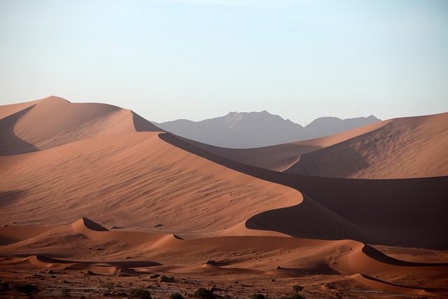
What sets Namibia's Desert apart from other deserts in the world is its unique characteristics and features. Spanning over 55,000 square miles, it is home to some of the tallest and most spectacular sand dunes in the world, reaching heights of up to 1,000 feet. These dunes are constantly being reshaped by the wind, creating an ever-changing landscape that is both mesmerizing and surreal. The desert also boasts a diverse range of habitats, from rocky outcrops to salt pans, providing a home to a variety of plant and animal life.

Despite its harsh environment, Namibia's Desert is considered a natural wonder due to its incredible resilience and adaptability. The plants and animals that call this desert home have evolved unique survival strategies to thrive in such extreme conditions. For example, the welwitschia plant, found only in the Namib Desert, can live for over 1,000 years by absorbing moisture from the morning fog. The desert is also home to a variety of desert-adapted animals, including the rare desert elephant, black rhino, and oryx. These species have developed thick skins and efficient water conservation methods to survive in the scorching heat and limited water resources.

The formation of Namibia's Desert has also played a crucial role in shaping the country's culture and history. The San people, who are indigenous to the desert, have lived in harmony with this environment for thousands of years, developing a deep connection and understanding of its landscape. The desert is also home to a rich variety of flora and fauna, some of which are found nowhere else on Earth. Unfortunately, the desert's unique ecosystem and wildlife are facing threats such as climate change and human activities, making conservation efforts crucial to its survival.

In conclusion, the formation of Namibia's Desert is a testament to the Earth's enduring forces and the endless possibilities of nature. Its breathtaking landscapes, diverse habitats, and unique species make it an unparalleled destination for those seeking adventure and discovery. As we continue to unravel its mysteries and protect its wonders, one thing is certain – Namibia's Desert will continue to captivate and amaze us for generations to come.

The Flora and Fauna of Namibia's Desert

The Namib Desert, known for its vast stretches of sand dunes and rugged landscapes, may seem like a barren and lifeless place. But, as we delve deeper into its mysterious depths, we discover a surprising abundance of flora and fauna that call this harsh environment their home.

The desert is home to a diverse range of plant life, from hardy succulents to unique endemic species. The most iconic plant of the Namib Desert is the Welwitschia plant, also known as “the living fossil.” This ancient plant can live for over 1,000 years, with some specimens estimated to be over 2,000 years old. Other common plants found in the desert include the quiver tree, with its distinctive shape and bark used for traditional arrow making, and the Nara melon, a vital source of food and water for both animals and humans.

Despite the harsh conditions, the Namib Desert is also home to a variety of animal species. The most famous of these is the desert-adapted elephant, which has evolved to survive in the arid environment by digging for water and storing it in their bodies. Other notable inhabitants include the oryx, a large antelope with distinctive long horns, and the elusive desert-adapted lion, who has adapted to the harsh climate by hunting at night and resting during the scorching daytime heat.

One of the most fascinating aspects of the flora and fauna in the Namib Desert is their incredible adaptations to survive in such a challenging environment. For instance, the desert-adapted elephant's large ears help regulate their body temperature, and their thick skin protects them from the harsh sun. Many plant species in the desert have also evolved to retain water, such as the Welwitschia plant, which has long taproots that can reach deep into the ground to access water.

However, not all species in the Namib Desert have been able to adapt to their surroundings. The desert lions, in particular, face many challenges, including a lack of prey and human-wildlife conflict. These factors have led to their classification as “vulnerable” on the IUCN Red List. Efforts are being made to protect and preserve these unique and threatened species, such as through responsible tourism practices and conservation initiatives.

The Namib Desert is also steeped in myths and legends surrounding its flora and fauna. The Welwitschia plant, for example, is believed to have mystical powers, and its leaves are used in traditional medicine by local communities. The desert elephant is also revered by the Himba people, who believe it is a sacred animal.

In conclusion, the Namib Desert may seem like a barren landscape, but it is teeming with life, from ancient plants to unique and resilient animals. These species have adapted to survive in one of the harshest environments on earth, making the Namib Desert a truly remarkable and awe-inspiring place.

The Mysteries and Legends of Namibia's Desert

The Namib Desert of Namibia is a land of enchantment and intrigue. With its vast expanse of sand dunes and barren landscape, it has captured the imagination of many for centuries. But beyond its awe-inspiring beauty, the desert is also shrouded in mysteries and legends that have been passed down through generations. In this section, we will explore some of the most fascinating tales and beliefs surrounding Namibia's Desert Mystery.

One of the most enduring mysteries of the Namib Desert is the “Fairy Circles.” These are circular barren patches of land, ranging from a few meters to over 100 meters in diameter, scattered throughout the desert. For years, scientists were baffled by these strange formations, with theories ranging from termites to radioactive sand. However, the local Himba people have their own explanation – they believe that the circles are created by the gods, who use them as a gathering place for dancing and celebrations. While the scientific explanation for these circles has since been discovered (sand termites, as it turns out), the legend lives on, adding to the mystique of the desert.

The Himba people also have a legend about the “Fire Mountains” of the Namib Desert. These are massive sand dunes that appear to be on fire, with the bright red sand glowing in the sunlight. According to the legend, these dunes were created by the fire god Mukuru, who scorched the earth to punish the people for their sins. Today, these dunes are a popular tourist attraction, with visitors marveling at their fiery beauty and learning about the Himba's beliefs.

The Namib Desert is also home to the famous “Welwitschia Mirabilis,” a plant that has captured the curiosity of many due to its bizarre appearance and long lifespan. This plant only has two leaves that grow continuously from a central stem, giving it a unique appearance. According to local legend, these plants are the tears of a young girl who was heartbroken when her lover left her. The gods took pity on her and turned her into a plant, so she could always watch over her beloved. While this may not be the most scientific explanation, it adds to the allure of this fascinating plant.

The local communities of Namibia also have superstitions and beliefs surrounding certain animals in the desert. For instance, the black cobra is considered a sacred animal and is believed to be a messenger of the gods. Killing a black cobra is said to bring bad luck and misfortune. Similarly, the desert scorpion is considered a symbol of good luck, and many people keep them as pets or wear them as jewelry for protection. These beliefs may seem unusual to outsiders, but they hold significant importance in the culture and traditions of the desert communities.

Apart from legends and beliefs, the Namib Desert is also home to some unexplained phenomena and sightings. The most famous of these is the “Brave Little Tailor,” a mysterious figure that is said to roam the desert, dressed in old-fashioned clothes and carrying a sewing machine. Many people have reported seeing this figure, with some even claiming to have spoken to him. The origin of this legend is unknown, but it adds to the sense of mystery and wonder surrounding the desert.

In conclusion, the Namib Desert is not just a barren landscape of sand and dunes; it is a land filled with myths, legends, and mysteries. These tales and beliefs add depth and character to the desert, making it a truly unique and enchanting place. So when you visit Namibia's Desert Mystery, take some time to immerse yourself in its rich folklore and ancient traditions. You never know what secrets you may uncover in this fascinating land.

The Impact of Namibia's Desert on the Environment

Namibia's desert, also known as the Namib, is a natural wonder that covers over 31,000 square miles of the African continent. This vast expanse of sand and rocks has a unique ecosystem that has been shaped by millions of years of geological events. The desert's impact on the environment is undeniable, and it has a crucial role to play in the delicate balance of our planet's ecosystem.

One of the most significant impacts of Namibia's desert is its role in regulating and maintaining the global climate. The Namib desert's proximity to the Atlantic Ocean creates a unique climate that affects the world's weather patterns. The cold ocean currents that run along the Namibian coast combine with the hot desert air to create the famous coastal fog, also known as the “desert breath.” This fog is a vital source of moisture for the plants and animals that call the desert home, and it also plays a crucial role in cooling down the surrounding areas, preventing droughts, and mitigating the effects of climate change.

The Namib desert is also home to a diverse range of plant and animal species, many of which are endemic and found nowhere else in the world. These species have adapted to the harsh conditions of the desert, including extreme temperatures, scarce water, and strong winds. Some of the most iconic plants in the desert are the Welwitschia, a slow-growing evergreen plant that can live up to 2000 years, and the quiver tree, which has adapted to store water in its trunk to survive through long periods of drought. The desert also boasts a variety of unique animals, including the desert elephant, the Hartmann's mountain zebra, and the critically endangered black rhinoceros. These species rely on the desert's fragile ecosystem for their survival, making it essential to preserve and protect the Namib's environment.

However, Namibia's desert is facing various threats and challenges that could have a severe impact on its ecosystem. Climate change, unsustainable land use practices, and human activities such as mining and poaching are all threatening the survival of the desert and its inhabitants. The desert's delicate balance is easily disrupted, and any changes could have far-reaching consequences for the entire ecosystem. Therefore, there are ongoing efforts to conserve and protect the Namib's environment, such as community-driven conservation projects, sustainable tourism initiatives, and strict regulations on natural resource extraction.

The Namib desert has also become a popular destination for tourists, with many seeking to experience its unique landscape and wildlife. However, with the increase in tourism, there is a concern for the desert's fragile environment, and the importance of responsible tourism practices cannot be overstated. Sustainable tourism initiatives, such as eco-friendly accommodations and responsible tour operators, are essential to minimize the impact of tourism on the desert's ecosystem.

In addition to its impact on the environment, Namibia's desert has also been a source of scientific discoveries and advancements. Researchers have discovered ancient fossils that have provided valuable insights into the evolution of various species, including humans. The desert's extreme conditions have also made it an ideal location for testing technologies and conducting experiments, leading to groundbreaking discoveries in fields such as astronomy and climate change.

In conclusion, Namibia's desert is more than just a vast expanse of sand and rocks; it is a crucial part of our planet's ecosystem. Its impact on the environment, both locally and globally, cannot be overstated. The desert's unique characteristics and features, its diverse flora and fauna, and its contribution to scientific discoveries make it a natural wonder that must be treasured and protected for generations to come.

Exploration and Tourism

Namibia's desert is not just a barren wasteland, but a captivating landscape that draws in adventurers and curious travelers from all over the world. The harsh conditions of the desert may seem like a deterrent to some, but for many, it is the very challenge that makes it all the more intriguing. In this section, we will delve into the various ways people can explore and experience Namibia's desert, as well as the importance of responsible tourism in preserving this natural wonder.

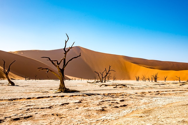
One of the most popular ways to experience the desert is through guided tours. These tours allow visitors to navigate through the vast expanse of the desert while learning about its history, geology, and unique features. With knowledgeable guides leading the way, visitors can safely explore the desert and witness its breathtaking sights. These tours often include stops at popular destinations such as the Sossusvlei and Deadvlei, where travelers can marvel at the towering sand dunes and the iconic dead trees that have become a symbol of the desert.

For the more adventurous souls, trekking and camping in the desert are also popular options. This allows for a more immersive experience, where visitors can truly appreciate the vastness and beauty of the desert. Camping under the starry skies and waking up to the orange hues of the sunrise over the dunes is an experience like no other. However, it is important to note that proper preparation and caution are crucial when undertaking such activities in the desert.

Another unique way to explore Namibia's desert is through hot air balloon rides. This offers a bird's eye view of the desert, allowing visitors to take in the full scale of its grandeur. It is also a great option for those who prefer a more leisurely and comfortable experience. As the balloon gently glides over the desert, travelers can witness the changing landscape and stunning natural formations from a unique perspective.

Aside from exploration, the desert also offers a range of activities for tourists to partake in. From sandboarding and quad biking to camel rides and stargazing, there is something for everyone in Namibia's desert. These activities not only provide an exciting and memorable experience but also support the local economy, providing employment opportunities for the communities living in and around the desert.

However, with the increasing popularity of tourism in the desert, it is important to consider the impact it has on the environment and the local communities. Irresponsible tourism can lead to littering, disturbance of wildlife, and damage to delicate ecosystems. It is crucial for visitors to be mindful of their actions and to follow the principles of responsible tourism, such as minimizing waste, respecting wildlife, and supporting local businesses.

In conclusion, the desert of Namibia offers endless opportunities for exploration and adventure. From guided tours to camping and hot air balloon rides, there is no shortage of ways to experience this natural wonder. It is important for visitors to approach these activities with responsibility and respect for the environment and local communities, ensuring the preservation of this mysterious and awe-inspiring landscape for generations to come.

Scientific Discoveries

The Namib Desert of Namibia is a land of mystery and wonder, filled with unique landscapes and fascinating biodiversity. But beyond its physical beauty, the desert also holds numerous scientific discoveries that have captured the attention of researchers and scientists from around the world. In this section, we will delve deeper into these jaw-dropping scientific discoveries and their implications for our understanding of the desert and its place in the world.

One of the most significant scientific discoveries in Namibia's desert is the presence of ancient fossils that provide crucial evidence of the region's prehistoric past. The desert's arid conditions have preserved these fossils for millions of years, allowing scientists to study them and unravel the secrets of the desert's ancient inhabitants. These fossils include the remains of ancient plants, dinosaurs, and even early humans, providing a glimpse into the evolution of life in the desert over millions of years.

Moreover, Namibia's desert is also home to some of the oldest living organisms on the planet – the Welwitschia plants. These unique plants can live for over 2,000 years and are only found in the desert's harsh conditions. Their longevity and adaptability have fascinated scientists, who are studying their genetic makeup and resilience to gain insights into their survival strategies. The discovery of these ancient plants has also shed light on the history of the desert's changing climate and how it has sustained life over the centuries.

In recent years, Namibia's desert has also become a hotspot for astronomical research and discoveries. The desert's clear skies and minimal light pollution make it an ideal location for stargazing and studying the universe. In fact, the desert is home to one of the world's largest optical telescopes, which has made groundbreaking discoveries, including the detection of distant galaxies and the study of black holes.

But perhaps the most astonishing scientific discovery in Namibia's desert is the presence of a massive underground lake deep beneath the desert's surface. This lake, known as the “Lost Eden,” was discovered in 2013 and is estimated to be around 10,000 years old. Its existence challenges our understanding of the desert's ability to support life and raises questions about the potential for discovering other hidden water sources in the region.

Furthermore, the desert's unique climate and geological features have also led to the discovery of new species and adaptations that have never been seen before. Scientists have found new species of insects, spiders, and reptiles that have evolved to survive in the desert's extreme conditions. These discoveries not only add to the desert's biological diversity but also provide insights into how life can thrive in seemingly inhospitable environments.

In conclusion, Namibia's desert has proven to be a treasure trove of scientific discoveries, offering valuable insights into the history, evolution, and ecology of this unique ecosystem. With ongoing research and exploration, it is likely that many more jaw-dropping discoveries will be made in the future, further cementing the desert's place as one of the world's most fascinating natural wonders.

0 comment
0 FacebookTwitterPinterestEmail

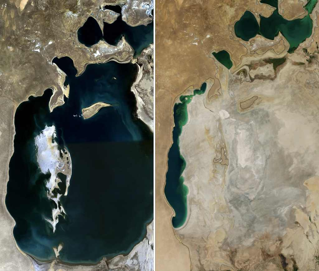
The Aral Sea, once one of the world's largest lakes, has undergone a dramatic transformation in the past few decades. What used to be a flourishing ecosystem and a vital source of livelihood for the people of Central Asia, has now become a symbol of environmental degradation and human impact.

In this article, we will delve into the rise and fall of the Aral Sea, uncovering its fascinating historical facts and tragic decline.

Through a comprehensive exploration of its past, we aim to shed light on the significance of understanding the consequences of human actions on our environment. As we uncover the story of the Aral Sea, we hope to learn valuable lessons that can guide us towards a more sustainable and responsible future.

The Aral Sea: A Historical Overview

The Aral Sea, once the fourth-largest lake in the world, holds a significant place in the history of Central Asia. Located between Kazakhstan and Uzbekistan, the Aral Sea has been a crucial source of livelihood for the people of the region for centuries. However, its importance and existence have been greatly impacted by human activities in the past few decades. In this section, we will delve into the origins and early history of the Aral Sea and explore its cultural, environmental, and economic significance in the region.

The Origins and Early History of the Aral Sea

The Aral Sea has a rich history that dates back to the ancient Silk Road era. The sea was formed over 5 million years ago when the Amu Darya and Syr Darya rivers flowed into a large basin known as the Ponto-Aral Sea. Over the centuries, the sea has been an important source of trade and transportation for the people living along its shores. It also provided a vital habitat for various species of fish and birds, making it a popular site for fishing and bird-watching.

The Significance of the Aral Sea in Central Asia

The Aral Sea's central location in the heart of Central Asia has been crucial for the region's economy and development. It served as a major hub for trade between Europe and Asia, with merchants trading silk, spices, and other goods through its ports. Additionally, the fertile lands surrounding the sea supported a thriving agricultural industry, providing food for both local consumption and export.

Moreover, the Aral Sea has played a significant role in the cultural history of the region. The sea has been a source of inspiration for artists, writers, and poets, with many ancient myths and tales centered around its shores. The local communities also had a deep spiritual connection with the Aral Sea, considering it a sacred and vital part of their lives.

The Role of the Aral Sea in Agriculture and Trade

In the late 19th century, the Russian Empire began large-scale irrigation projects around the Aral Sea, aiming to transform the region into a major agricultural center. However, it was during the Soviet era that the Aral Sea's role in agriculture and trade truly flourished. The Soviet government implemented massive irrigation projects to grow cotton, a cash crop that became the backbone of their economy. This led to a rapid increase in water diversion from the sea, resulting in the Aral Sea's water level starting to decline.

The Consequences of Water Diversion

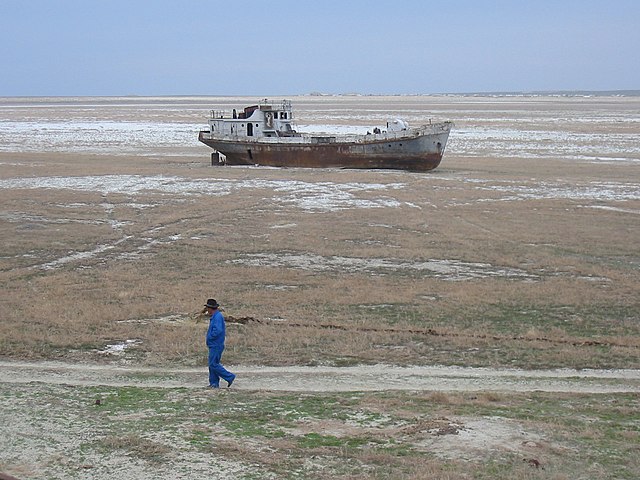
As the Soviet Union focused on industrialization and agriculture, the Aral Sea paid the price. The diversion of water from the rivers feeding into the sea led to a decrease in water levels, causing the sea to shrink in size. This had a devastating impact on the surrounding ecosystem, with many species of fish dying due to the increased salinity of the water. The once-thriving fishing industry also collapsed, affecting the livelihoods of the communities living along the shore.

Moreover, the decline of the Aral Sea had severe economic and environmental consequences. The exposed seabed became a breeding ground for toxic dust storms, leading to increased health risks for the local population. The region also experienced a rise in desertification, causing a loss of fertile lands and biodiversity. These consequences continue to affect the region to this day.

Thus, the Aral Sea's history is a cautionary tale of the consequences of unchecked human activities. In the next section, we will explore the decline of the Aral Sea in detail and uncover the efforts made to document and address this tragic decline.

The Rise of the Aral Sea

The Aral Sea, located in Central Asia, has a long and rich history. It has been an integral part of the region's culture, environment, and economy for centuries. In this section, we will explore the rise of the Aral Sea and its importance in the development of Central Asia.

The origins of the Aral Sea can be traced back to the prehistoric times when it was part of a larger system of lakes and rivers. However, it was not until the 13th century that the sea was mentioned in historical records. At that time, the Aral Sea served as a vital transport route for traders traveling along the Silk Road. Its strategic location made it a hub for commerce, connecting the East and the West.

During the 19th century, the Aral Sea played a significant role in the development of agriculture in the region. The fertile land surrounding the sea was used for cotton production, which became the main source of income for the local population. This led to the growth of cities and towns around the Aral Sea, making it a center of trade and economic activity.

However, it was not until the 20th century when the Aral Sea's rise truly began. Under the Soviet Union's rule, the Aral Sea region was designated as a priority area for industrialization and agricultural development. The Soviet government invested heavily in irrigation projects, aiming to transform the region into a major agricultural hub. This resulted in the construction of dams, canals, and other water diversion projects, all aimed at increasing the flow of water into the Aral Sea.

The increase in water diversion had a significant impact on the Aral Sea. It led to a rise in its water level, which was seen as a positive development at the time. The sea's expanding shores were seen as a sign of progress and prosperity for the region. However, this was short-lived.

As the sea's water level rose, the surrounding land became increasingly saline, making it unsuitable for agriculture. This, combined with poor irrigation practices, led to a decrease in crop yields and the degradation of the soil. The Aral Sea's rising water level also threatened the unique ecosystem of the sea, affecting the fish population and other wildlife.

In the 1960s, the sea's rise reached a critical point, and the consequences began to emerge. The increased water diversion caused the Aral Sea's water level to decline rapidly, exposing the sea's seabed and devastating the local fishing industry. This marked the beginning of the Aral Sea's decline, which had severe environmental and economic consequences for the region.

In conclusion, the rise of the Aral Sea was a result of the region's historical, cultural, and economic significance. However, the Soviet Union's industrialization and agricultural policies had a profound and detrimental effect on the sea's ecosystem. In the next section, we will explore the tragic decline of the Aral Sea and its impact on the surrounding communities.

The Fall of the Aral Sea

The period of the 1960s marked the beginning of the Aral Sea's tragic decline. This was a result of the Soviet Union's ambitious plan to transform the Aral Sea region into a major agricultural hub. The construction of irrigation canals to divert water from the two main rivers feeding into the sea, the Amu Darya and Syr Darya, was a key component of this plan.

As a result, the water level in the Aral Sea began to drop rapidly, leading to a series of devastating consequences. The decline of the Aral Sea can be attributed to several factors, including the increase in water diversion projects, inefficient irrigation practices, and the lack of proper planning and management.

The diversion of water from the rivers to the agricultural fields caused a significant decrease in the water flow into the Aral Sea. As a result, the sea's water level dropped by an alarming rate of up to 20 centimeters per year. This caused the shoreline to recede by more than 60 kilometers, leaving behind large areas of salty and barren land.

The decrease in water flow also had a severe impact on the Aral Sea's ecosystem. The salt and mineral content of the remaining water increased, making it too salty for most aquatic life to survive. This led to the extinction of many species of fish, including the once abundant sturgeon, as well as the loss of important wetland habitats for migratory birds.

The decline of the Aral Sea also had significant economic consequences for the region. The sea was once a major source of fish, providing livelihoods for thousands of people. With the decrease in fish populations, many lost their source of income and were forced to find alternative means of survival. The decline in the sea's water level also affected the climate, leading to an increase in dust storms and desertification, further impacting the region's economy.

The environmental and economic consequences of the Aral Sea's decline were not limited to the immediate region. The shrinking sea also had a global impact, as the dust and salt particles carried by the wind spread to other areas, causing air pollution, health issues, and damaging crops.

Despite the obvious consequences of the Aral Sea's decline, little action was taken to address the issue until the late 1980s. By then, it was too late to reverse the damage that had been done. Efforts were made to restore the water flow into the sea, but they proved to be insufficient due to the years of neglect and mismanagement.

In conclusion, the fall of the Aral Sea was a tragic event that had significant environmental, economic, and social consequences. It serves as a stark reminder of the dangers of unsustainable development and the need for responsible resource management. The decline of the Aral Sea stands as a cautionary tale and serves as a lesson for future generations to prioritize the preservation of our natural resources.

Uncovering the Historical Facts

The decline of the Aral Sea is a tragic event that has captured the attention of the world in recent decades. Once the fourth-largest lake in the world, the Aral Sea has shrunk to less than a quarter of its original size, leaving behind a barren landscape and devastating consequences for the surrounding communities. To truly understand the magnitude of this environmental disaster, it is important to uncover the historical facts and uncover the truth about the Aral Sea's decline.

In the early 20th century, the Aral Sea was a thriving body of water situated in Central Asia, bordered by Kazakhstan and Uzbekistan. It played a significant role in the region's history, serving as a vital trade route and an essential source of water for agriculture. The sea's rich biodiversity also made it an important cultural and environmental site for the local communities.

However, with the onset of industrialization in the 1960s, the fate of the Aral Sea took a dramatic turn. The Soviet Union, in an attempt to boost agricultural production in the region, began diverting water from the two rivers that fed into the Aral Sea. These diversion projects were meant to channel water towards the vast cotton fields in the desert, leaving little to no water to replenish the sea. This marked the beginning of the Aral Sea's decline.

Satellite imagery has played a crucial role in documenting the changes in the Aral Sea over the years. In the 1980s, satellite images revealed the alarming decrease in the Aral Sea's water level, and by the 1990s, it had shrunk by 60%. This data provided undeniable evidence of the sea's decline, and scientists and researchers began to study the effects of this environmental disaster.

Through their findings, scientists have uncovered that the Aral Sea's decline has had a ripple effect on the surrounding ecosystem. The decrease in water level has led to a rise in salinity, making the remaining water undrinkable and causing the extinction of many aquatic species. The exposed seabed has also led to severe dust storms, further exacerbating the environmental impact.

Moreover, the decline of the Aral Sea has had severe consequences for the communities that once depended on it. The shrinking sea has left behind a barren landscape, rendering the previously fertile land unproductive. This has resulted in the displacement of thousands of people and the collapse of local economies. The increase in salinity has also led to health issues for those living in the region.

The decline of the Aral Sea serves as a poignant reminder of the consequences of unsustainable resource management. It highlights the need for responsible environmental practices and sustainable development to prevent similar tragedies from occurring in the future. International cooperation and support are necessary in addressing environmental issues and mitigating their impact on communities and ecosystems.

In conclusion, uncovering the historical facts of the Aral Sea's decline is crucial in understanding the severity of this environmental disaster. Thanks to the efforts of scientists and researchers, we now have a better understanding of the factors that have contributed to its decline. It is now up to us to learn from this tragedy and take proactive steps towards preserving our planet's natural resources for future generations.

Tracing the Tragic Decline

The decline of the Aral Sea has been a slow and tragic process that has had devastating effects on the surrounding communities and their way of life. As the sea's water level continued to decrease, the once-thriving fishing industry collapsed, leaving many people without a source of income. The decline of the Aral Sea has also had a severe impact on the region's agriculture, leading to economic and health consequences for the local population.

One of the most significant effects of the Aral Sea's decline has been the deterioration of the region's health. The shrinking sea has left behind a vast area of exposed seabed, which contains high levels of salt and toxic chemicals from years of agricultural runoff. As the water receded, winds swept the salt and chemicals into the air, causing respiratory issues and other health problems for the surrounding communities. Additionally, the loss of the sea has disrupted the region's climate, leading to extreme temperatures and desertification, making it difficult for people to grow crops or maintain their traditional pastoral way of life.

The economic consequences of the Aral Sea's decline have been equally devastating. As the sea's water level decreased, so did the fish population, leaving many fishermen without a livelihood. The decline of the fishing industry also had a ripple effect on other sectors of the economy, such as transportation and processing plants, leading to mass unemployment in the region. The loss of the sea's water has also affected the irrigation systems of nearby agricultural areas, resulting in lower crop yields and further economic hardships for the local population.

In response to the crisis, international organizations and governments have stepped in to address the tragic decline of the Aral Sea. The World Bank and the United Nations have collaborated with the governments of Kazakhstan, Uzbekistan, and other Central Asian countries to implement projects aimed at improving the region's water management and environmental conditions. These efforts have included the construction of dams and canals to redirect water back into the Aral Sea and the introduction of sustainable farming techniques to improve crop yields.

However, while these efforts have had some success in slowing down the decline of the sea, the damage has already been done. The lessons learned from the Aral Sea's decline are crucial in understanding the importance of sustainable development and responsible resource management. The overuse and mismanagement of resources, in this case, water, can have catastrophic consequences on both the environment and the livelihoods of the people who depend on it.

In conclusion, the tragic decline of the Aral Sea serves as a cautionary tale of the devastating effects of human activity on the environment. It highlights the need for international cooperation and responsible resource management to prevent similar disasters from occurring in the future. The Aral Sea may never fully recover, but it serves as a reminder of the importance of protecting and preserving our natural resources for generations to come.

Lessons to be Learned

The tragic decline of the Aral Sea serves as a stark reminder of the consequences of unsustainable development and irresponsible resource management. The continuous diversion of water for agricultural purposes, without considering the long-term impact on the ecosystem, has led to the devastating decline of the sea. This serves as a lesson for all of us to learn from and take action to prevent similar disasters from happening in the future.

One of the key lessons to be learned from the Aral Sea's decline is the importance of sustainable development. This means using resources in a way that meets the needs of the present without compromising the ability of future generations to meet their own needs. The Soviet Union's agricultural practices in the Aral Sea region were not sustainable, and the consequences are evident to this day. It is crucial for governments and industries to prioritize sustainable practices in order to prevent such disasters.

Moreover, the Aral Sea's decline highlights the need for responsible resource management. The excessive diversion of water from the two main rivers that feed the sea, the Amu Darya and the Syr Darya, has caused irreparable damage to the ecosystem. It is essential for all parties involved to consider the long-term impact of their actions on the environment and implement measures to mitigate any negative effects.

Another lesson to be learned from the Aral Sea's decline is the importance of international cooperation in addressing environmental issues. The Aral Sea is shared by Kazakhstan and Uzbekistan, and the diversion of water from the rivers has also affected neighboring countries such as Turkmenistan and Tajikistan. This highlights the need for collaborative efforts between governments to address transboundary environmental issues. The Aral Sea crisis has prompted international organizations such as the United Nations and the World Bank to provide support and aid in addressing the situation.

The tragic decline of the Aral Sea has also brought to light the importance of proper monitoring and data collection. Thanks to advancements in technology, scientists and researchers were able to document the decline of the sea using satellite imagery. This data has been crucial in understanding the extent of the Aral Sea's decline and has aided in the development of strategies to address the crisis. It is essential for governments and organizations to invest in proper monitoring and data collection to effectively address environmental issues.

Furthermore, the decline of the Aral Sea highlights the interconnectedness of the environment and human health. The shrinking of the sea has led to an increase in air pollution, as the exposed sea bed has become a major source of dust storms in the region. This has had severe consequences on the health of the surrounding communities, leading to an increase in respiratory diseases. This serves as a reminder that our actions towards the environment have a direct impact on our health and well-being.

In conclusion, the tragic decline of the Aral Sea has paved the way for valuable lessons to be learned. It serves as a reminder of the importance of sustainable development, responsible resource management, international cooperation, proper monitoring and data collection, and the interconnectedness of the environment and human health. It is crucial for governments, industries, and individuals to take these lessons to heart and work towards a more sustainable and responsible future. Let the rise and fall of the Aral Sea serve as a warning and a call to action for all of us to take better care of our environment.

0 comment
0 FacebookTwitterPinterestEmail

Welcome to Mount Rushmore, a towering monument that stands as a symbol of American history and culture. As one of the most iconic landmarks in the United States, Mount Rushmore has captivated visitors from all around the world with its monumental majesty and rich history. In this article, we will take you on a journey to explore this national treasure and delve into its cultural significance.

From the making of the monument to the experience of visiting, we will provide you with all the information you need to plan an unforgettable trip to Mount Rushmore. So pack your bags and get ready to embark on a journey into American history at Mount Rushmore.

The Making of Mount Rushmore

The creation of Mount Rushmore was a monumental undertaking that had profound cultural and historical significance for the United States. Located in the Black Hills of South Dakota, Mount Rushmore features the faces of four iconic American presidents – George Washington, Thomas Jefferson, Theodore Roosevelt, and Abraham Lincoln – carved into the granite rock face. Each of these presidents played a significant role in shaping the nation, making Mount Rushmore a symbol of American greatness and achievement.

The idea for Mount Rushmore was first proposed in the 1920s by South Dakota historian Doane Robinson. He envisioned the monument as a way to promote tourism in the state and attract visitors to the Black Hills. However, it was Gutzon Borglum, a renowned sculptor, who was commissioned to bring Robinson's vision to life. Borglum, along with his son Lincoln Borglum, spent 14 years working on the project, from 1927 to 1941.

The initial plans for Mount Rushmore included depictions of iconic figures from American history such as Lewis and Clark, Red Cloud, and Buffalo Bill Cody. However, Borglum ultimately decided on the four presidents as they represented the birth, growth, preservation, and development of the United States. Each president was also carefully selected for their contributions to the country and their lasting impact on American values.

The construction of Mount Rushmore was a challenging and dangerous feat. The sculptors had to scale the sheer granite face using ropes and pulleys, with no safety harnesses or modern tools. They used dynamite to blast away large portions of the rock and then meticulously chiseled and shaped the faces using drills and jackhammers. This work was not without its controversies, as it involved destroying a sacred mountain to the Lakota Sioux, who consider the Black Hills their spiritual home.

Despite the challenges, Borglum and his team persevered and continued their work on the monument. Unfortunately, Borglum passed away in 1941 before the project could be completed. His son, Lincoln, took over and worked on the monument for another six months before it was declared completed. The monument stands at 60 feet tall and each president's face measures around 60 feet from chin to forehead.

Today, Mount Rushmore is a popular tourist destination and a symbol of American pride and history. It receives over 3 million visitors each year, who come to marvel at the incredible feat of engineering and pay homage to the iconic presidents. The monument also serves as a reminder of the determination and vision of the individuals involved in its creation, and the enduring legacy of the United States.

Overall, the making of Mount Rushmore is a testament to the perseverance, skill, and determination of those involved in its creation. It is a breathtaking representation of American history and a must-see for anyone wanting to explore the cultural and historical significance of the United States.

Discovering the Monuments

As you approach Mount Rushmore, its grandeur and significance are immediately evident. The iconic landmark is a symbol of American history and patriotism, and its four presidents hold a special place in the hearts of many. In this section, we will delve into the creation and meaning of the magnificent sculptures that make up Mount Rushmore.

The Layout and Design:

Designed by sculptor Gutzon Borglum, Mount Rushmore features the towering faces of Presidents George Washington, Thomas Jefferson, Theodore Roosevelt, and Abraham Lincoln, carved into the granite face of the Black Hills in South Dakota. The monument stands at a staggering height of 60 feet and spans 500 feet across, making it one of the largest sculptures in the world.

Each president's face is intricately carved to capture their unique features and personalities. Washington, known as the “Father of Our Country,” stands at the center of the monument, with Jefferson, the author of the Declaration of Independence, to his left. On Jefferson's right is Roosevelt, regarded as a pioneer of conservation, and finally, Lincoln, the Great Emancipator, completes the powerful lineup.

Symbolism and Meaning:

The sculptor's vision behind the inclusion of these particular presidents was to represent the birth, growth, development, and preservation of the United States. Each president also represents a significant period in American history, with Washington and Jefferson representing the birth of the nation, Roosevelt symbolizing its growth and development, and Lincoln symbolizing its preservation during the Civil War.

In addition to their symbolic significance, each president's placement on the monument also holds meaning. Washington and Jefferson are placed on the left side of the monument, representing the East and the birth of the nation, while Roosevelt and Lincoln are placed on the right, representing the West and the country's expansion.

Interesting Facts and Anecdotes:

The creation of Mount Rushmore was no small feat. It took 14 years to complete and involved over 400 workers. The original plan was to include the presidents' full bodies, but due to funding constraints, the project was scaled down to just their faces. The project also faced numerous challenges, including harsh weather conditions, limited resources, and the difficult terrain.

One interesting fact about the construction of Mount Rushmore is that the sculptor's studio, located at the base of the monument, was used as a workshop and a home for Borglum and his workers during the project. Today, visitors can tour the studio and see the tools and equipment used for the carving.

Another fascinating aspect of Mount Rushmore is its ongoing maintenance. Due to the effects of weather and erosion, the monument requires constant upkeep, including cleaning and repairing any damages. This ensures that future generations can continue to appreciate the monument's grandeur and significance.

In conclusion, discovering the monuments of Mount Rushmore is a truly awe-inspiring experience. The layout and design, symbolism and meaning, and interesting facts surrounding the creation and maintenance of the sculptures make it a must-visit destination for anyone interested in American history and culture. So, what are you waiting for? Plan your trip to Mount Rushmore and be prepared to be blown away by its monumental majesty.

Journey to Mount Rushmore

Located in the Black Hills of South Dakota, Mount Rushmore is one of the most iconic and recognizable landmarks in the United States. Its grandeur and cultural significance make it a must-visit destination for anyone looking to explore the rich history of America. In this section, we will guide you on your journey to Mount Rushmore, from getting there to experiencing its monumental majesty.

How to Get There:

Mount Rushmore is easily accessible by car, located 35 miles from the nearest major airport in Rapid City. Many visitors choose to rent a car and make the scenic drive through the Black Hills National Forest to reach the monument. However, for those who prefer not to drive, there are also shuttle buses and tours available from surrounding cities such as Deadwood, Keystone, and Custer. These options also offer a chance to learn more about the history and culture of the area from knowledgeable guides.

Where to Stay:

There are a variety of accommodation options in the surrounding areas of Mount Rushmore, from cozy cabins to luxury hotels. For those looking to stay closer to nature, there are also campgrounds and RV parks available in the nearby state parks. Whichever option you choose, make sure to book in advance, especially during peak travel season.

Exploring the Surrounding Area:

While the main attraction is Mount Rushmore, the surrounding area has much to offer for visitors. Some popular nearby attractions include the Crazy Horse Memorial, Custer State Park, and the historic town of Deadwood. These destinations offer an insight into Native American culture, stunning natural landscapes, and a taste of the Wild West history.

Tips for a Successful Trip:

To make the most of your trip to Mount Rushmore, here are some tips to keep in mind:

  • Arrive early in the day to avoid large crowds and secure a good parking spot.
  • Wear comfortable shoes as there is a short hike to reach the viewing area.
  • Bring sunscreen and a hat, as the South Dakota sun can be intense.
  • Plan to spend at least a few hours at the monument to fully explore and take in the experience.

Experiencing Mount Rushmore:

As you approach the monument, the first thing that will strike you is the sheer size and detail of the four presidents' faces carved into the granite mountainside. The entrance to the park is free, but there is a parking fee of $10 per vehicle. Once inside, you can take a leisurely walk along the Avenue of Flags and visit the Lincoln Borglum Visitor Center to learn about the monument's history and construction.

For a more interactive experience, don't miss the ranger-led talks and the Sculptor's Studio, where you can see the initial plans and models for the monument. The evening lighting ceremony is also a must-see, where the mountain is illuminated and a ranger shares stories about the monument's creation.

Cultural and Historical Significance:

Mount Rushmore holds great cultural and historical significance, not only for America but also for the surrounding Native American tribes. The monument was created as a tribute to the birth, growth, preservation, and development of the United States.

However, it is important to acknowledge the controversies and criticisms surrounding the monument's representation and impact on indigenous peoples. Leaving a Lasting Impression: A trip to Mount Rushmore is an unforgettable experience that will leave a lasting impression on any visitor.

The majestic and intricate details of the monument, combined with its rich history and cultural significance, make it a must-see destination. As you leave the monument, take a moment to reflect on the impact and legacy of Mount Rushmore and add it to your travel bucket list for a truly unforgettable journey into American history.

Experiencing Mount Rushmore

Visiting Mount Rushmore is a once-in-a-lifetime experience that offers a unique glimpse into American history and culture. As you make your way to the monument, the anticipation builds, and the breathtaking views of the Black Hills National Forest only add to the excitement. But what can you expect when you finally arrive at this iconic landmark?

Entrance Fees and Activities:

Before you begin your journey to Mount Rushmore, it’s important to note that there is a fee for entrance to the monument. However, the fee is per vehicle and includes parking, so it’s a budget-friendly option for families or groups. Once inside, visitors can embark on a variety of activities to enhance their experience.

One of the most popular activities is the Presidential Trail, a half-mile loop that takes you closer to the monument and offers unique views of each president's face. Along the trail, you’ll also find informative plaques with interesting facts about Mount Rushmore and the presidents depicted on it.

Educational and Interactive Opportunities:

For those looking for a more educational experience, Mount Rushmore offers ranger-led talks and programs throughout the day. These talks cover topics such as the history of the monument and the cultural significance of each president. The Sculptor’s Studio is another must-visit for history buffs, as it provides a behind-the-scenes look at the tools and techniques used to create the monument.

For a more hands-on experience, visitors can participate in the Junior Ranger program, where kids can complete activities and earn a badge while learning about Mount Rushmore. There is also the Avenue of Flags, featuring the flags of all 50 states and territories, and the Borglum View Terrace, which provides panoramic views of the monument.

Breathtaking Views and Photo Opportunities:

One of the most unforgettable experiences at Mount Rushmore is the lighting ceremony held every evening at sunset. The monument is illuminated, while a ranger shares the history and significance of each president depicted on it. This is a truly magical and patriotic moment that should not be missed.

In addition to the lighting ceremony, there are plenty of opportunities for stunning photos at Mount Rushmore. The viewing deck offers the perfect vantage point to capture the iconic faces of the presidents, and the natural beauty of the surrounding area provides a picturesque backdrop for photos.

In conclusion, visiting Mount Rushmore is an experience that will stay with you long after you leave. From the educational and interactive opportunities to the breathtaking views and photo opportunities, there is something for everyone at this monumental site. So add Mount Rushmore to your travel bucket list, and prepare to be awe-struck by its significance and majesty.

The Cultural and Historical Significance of Mount Rushmore

Mount Rushmore is not just a monument carved into the side of a mountain, but a symbol of American history and culture. This iconic landmark holds a deep significance and has played a crucial role in shaping the country we know today. In this section, we will explore the cultural and historical importance of Mount Rushmore and its impact on American society.

For centuries, Native American tribes have inhabited the Black Hills region where Mount Rushmore is located. The creation of the monument sparked controversy and backlash from these tribes as the land was considered sacred to them. The Lakota Sioux in particular have strong ties to this land and have protested against the carving of Mount Rushmore for decades. Despite this, the monument stands today as a testament to the power and influence of American politics and culture.

The four presidents depicted on Mount Rushmore – George Washington, Thomas Jefferson, Abraham Lincoln, and Theodore Roosevelt – were chosen for their significant contributions to American history. These men represent crucial moments in the nation's development, such as the founding of the country, the expansion of its territory, the preservation of the Union, and the conservation of its natural resources.

Each president also holds a symbolic meaning on the monument. Washington represents the birth of the United States, Jefferson stands for the growth and expansion of the nation, Lincoln represents the preservation and unity of the country, and Roosevelt stands for the development and conservation of the nation's resources. Together, they embody the values and ideals that make up the American identity.

The construction of Mount Rushmore was a monumental feat, both technically and politically. The vision and determination of sculptor Gutzon Borglum and his team of workers to create such a massive monument on the side of a mountain is awe-inspiring. The monument has also faced several challenges and controversies, including funding issues, environmental concerns, and disagreements over which presidents to include.

Despite these challenges, Mount Rushmore has become one of the most iconic symbols of American nationalism and patriotism. Today, it welcomes millions of visitors each year who come to admire its grandeur and learn about the history it represents. The monument offers an educational and interactive experience, with ranger-led talks, a Sculptor's Studio, and opportunities to explore the surrounding Black Hills region.

Visiting Mount Rushmore leaves a lasting impression on its visitors. The breathtaking views of the monument and the surrounding Black Hills are unforgettable. The monuments themselves hold a certain aura and power, making it a must-see for anyone interested in American history and culture.

However, it is important to acknowledge the perspectives of the Native American tribes who have been displaced and impacted by the creation of Mount Rushmore. While the monument may hold great significance for many Americans, it is also a reminder of the struggles and injustices faced by indigenous peoples.

In conclusion, Mount Rushmore is more than just a tourist attraction. It is a symbol of America's past, present, and future. It represents the triumphs and struggles of the nation and serves as a reminder of the diverse perspectives and histories that make up the American identity. Visiting this monument is not only a journey into American history, but also a journey of self-reflection and understanding.

Leaving a Lasting Impression

As you stand in front of the towering granite sculptures of four iconic American presidents at Mount Rushmore, it's hard not to feel a sense of awe and wonder. The sheer grandeur of this national monument is enough to leave a lasting impression on any visitor. But beyond its physical beauty, Mount Rushmore holds a much deeper significance that resonates long after you leave.

Personal Reflections:

Many visitors leave Mount Rushmore with a newfound appreciation for American history and the presidents depicted on the monument. The larger-than-life faces of George Washington, Thomas Jefferson, Abraham Lincoln, and Theodore Roosevelt serve as a reminder of their leadership and contributions to the nation. As visitors walk along the Presidential Trail and take in the stunning views, it's hard not to reflect on the impact of these great men and their legacies.

Moreover, the experience of standing in front of such an iconic landmark, which took nearly 14 years to complete, is humbling. The intricate details and precision of the sculptures are a testament to the skill and dedication of the sculptor, Gutzon Borglum, and his team. This level of craftsmanship and perseverance is truly inspiring and leaves a lasting impression on all who visit.

Impact and Legacy:

Beyond the personal reflections, Mount Rushmore also has a significant cultural and historical impact. As one of the most recognizable symbols of the United States, it has become a must-visit destination for both domestic and international tourists. Its inclusion in popular culture, from movies to TV shows, has further solidified its status as a national treasure.

In addition, Mount Rushmore has also played a role in shaping the nation's identity and promoting unity. The monument serves as a reminder of the ideals and values that America stands for, and its grandeur brings people from all backgrounds together to appreciate its beauty and significance.

Add to Your Travel Bucket List:

As you leave Mount Rushmore, you can't help but feel that you've been a part of something truly special. The memories and emotions it evokes stay with you long after your visit, making it a truly unforgettable experience.

So, whether you're a history buff, nature lover, or simply looking for a unique travel destination, Mount Rushmore should definitely be on your travel bucket list. Its monumental majesty, cultural significance, and lasting impact make it a must-visit for anyone exploring American history and culture. Plan your trip now and prepare to be awestruck by this iconic landmark.

0 comment
0 FacebookTwitterPinterestEmail

Easter Island, an isolated and mysterious land in the Pacific Ocean, has captivated the world with its enigmatic past and secrets. This small island, also known as Rapa Nui, may be one of the most intriguing destinations on earth, drawing visitors from all corners of the globe. Its reputation as a place of mystery and wonder has only grown over the years, leaving many curious about its history and secrets.

In this article, we aim to delve into the unknown and unveil the secrets of Easter Island, shedding light on its fascinating past and present. Join us on this journey to discover the enigmatic island and uncover the mysteries that continue to intrigue and astound us.

Discovering the Enigmatic Island

Easter Island, also known as Rapa Nui, has long captured the imagination of explorers and travelers alike. This remote island, located in the Pacific Ocean, is famous for its enigmatic past and the iconic Moai statues that dot its landscape. Despite being one of the most isolated places on Earth, Easter Island has managed to capture the attention of the world and continues to be a source of intrigue and fascination. In this article, we will delve into the mysteries of Easter Island and uncover the secrets that have puzzled researchers for centuries.

The Geographical Location and Physical Features of Easter Island

Easter Island is located over 2,000 miles off the coast of Chile and covers an area of just 63 square miles. The island is of volcanic origin and is characterized by its rugged terrain, with three extinct volcanoes dominating its landscape. The island's remote location, surrounded by vast expanses of ocean, has played a significant role in shaping its enigmatic nature.

The isolation of Easter Island has meant that it remained untouched by outside influences for centuries. This has allowed the island's unique flora and fauna to thrive, creating a distinct ecosystem that can only be found on Rapa Nui. The island's isolation also meant that its inhabitants developed their own culture and way of life, which is now shrouded in mystery and intrigue.

The Significance of Isolation and Lack of Written Records

The lack of written records is one of the biggest challenges in piecing together the history of Easter Island. With no written language, the island's inhabitants relied on oral tradition to pass down their stories and history. However, with the eventual decline of the civilization, much of the island's knowledge and secrets were lost.

The island's isolation also played a significant role in the lack of written records. With no external contact, the islanders had no means of recording their history and culture, making it difficult for researchers to uncover the true origins of Easter Island and its people.

The Mystery of the Moai

The Moai statues are perhaps the most well-known and iconic feature of Easter Island. These massive stone figures, some weighing up to 80 tons, have puzzled researchers for centuries. How were they created? What was their purpose? These are just some of the questions that continue to baffle experts.

One theory suggests that the Moai were created to honor the ancestors of the island's inhabitants. Another proposes that they were used to mark sacred sites or as a representation of the island's gods. Regardless of their purpose, the Moai remain a source of fascination and continue to draw visitors to Easter Island.

Ongoing Archaeological Efforts

Despite the many theories surrounding the Moai, the true purpose and creation of these statues remain a mystery. However, ongoing archaeological efforts have shed some light on the topic. Researchers have discovered that the Moai were carved using only stone tools and were transported across the island using a system of ropes and log rollers.

These discoveries have not only helped to unravel the mystery of the Moai but have also provided insight into the island's past and the capabilities of its ancient inhabitants.

Unraveling the Mystery of the Moai

The Moai statues of Easter Island are perhaps the most iconic and mysterious aspect of this enigmatic island. These towering figures, with their distinctive features and solemn expressions, have captured the imagination of people around the world for centuries. But despite their fame, the purpose and creation of the Moai still remain a mystery.

The Moai, meaning “statues” in the local language, are believed to have been built between the 13th and 16th centuries by the Rapa Nui people. These massive statues can reach up to 33 feet in height and weigh up to 82 tons. It is estimated that there are around 900 Moai scattered across the island, many of which are still in their original quarries, unfinished and enigmatic.

One of the most intriguing aspects of the Moai is the mystery surrounding their purpose. The prevailing theory is that these statues were meant to represent ancestors or important figures in the Rapa Nui society. However, there are also many other theories, ranging from religious and spiritual significance to astronomical and navigational purposes.

The creation of the Moai is also a subject of much speculation. It is believed that these statues were carved out of volcanic tuff, a soft stone found on the island. But how were they transported and erected on top of massive platforms known as ahu? Some theories suggest they were rolled on logs or using ropes and pulleys, while others propose that they were “walked” to their designated locations with the use of ropes and manpower. Nevertheless, the sheer size and precision of the Moai's construction continue to baffle scientists and archaeologists.

Despite ongoing efforts, the exact purpose and methods of creating the Moai remain a mystery. However, recent archaeological excavations have shed some light on these enigmatic statues. Some of the uncovered statues revealed intricate carvings on their backs, indicating a possible connection to the Rongorongo script. This has led to further speculation that the Moai may have served a ceremonial or religious purpose, perhaps even acting as a form of communication with the gods.

The Moai also play a vital role in understanding the decline and collapse of the Rapa Nui civilization. Many statues have been found to have been toppled over, leading to the theory that the Rapa Nui people turned against their own ancestors in a time of crisis. Additionally, the carving and transportation of these colossal statues may have contributed to the depletion of the island's resources, leading to a societal collapse.

Despite their enduring mystery, the Moai continue to be a significant part of Easter Island's history and culture. Efforts are being made to preserve and protect these statues from further damage, including the creation of a Moai Conservation Program. This program aims to restore and maintain the Moai, ensuring they remain a symbol of the island's past for future generations.

In conclusion, the Moai of Easter Island continue to intrigue and fascinate us, with each new discovery bringing us closer to understanding their true purpose and significance. With ongoing research and exploration, we may one day uncover the secrets and mysteries behind these enigmatic statues, providing us with a deeper understanding of the Rapa Nui people and their intriguing island home.

The Rongorongo Script: A Lost Language

The Rongorongo script is a form of writing found on Easter Island, known for its mysterious and enigmatic nature. The script consists of glyphs, or symbols, that are carved into wooden tablets or other artifacts found on the island. However, despite its significance, the Rongorongo script remains a lost language, with little known about its origins and meaning.

There are several challenges in deciphering the Rongorongo script, including the fact that there is no known spoken language associated with it. This makes it difficult to compare it to other languages and decipher its meaning. Additionally, the number of surviving rongorongo texts is limited, with only 25 wooden tablets and a few other artifacts found with the script.

One of the most intriguing aspects of the Rongorongo script is the lack of knowledge about its origins. Some theories suggest that it may have been brought to the island by Polynesian migrants, while others propose that it was created by the Rapa Nui people themselves. However, without a spoken language to associate it with, the true origins of the Rongorongo script remain a mystery.

The symbols in the Rongorongo script are highly complex and have been described as resembling a mix of hieroglyphics and Chinese characters. Some of the glyphs are recognizable as animals or other objects, while others are more abstract. This has led to numerous attempts to decipher the script, but so far, no definitive translation has been achieved.

Despite the challenges, there have been some attempts to interpret the Rongorongo script. For instance, a study by the University of Hawai'i proposed that the script may be a form of mnemonic device, used to record important information such as genealogies or food storage. However, this theory remains widely debated and has yet to be fully accepted.

In addition to its linguistic significance, the Rongorongo script is also crucial in understanding the history and culture of Easter Island. It is believed that the script was used by the Rapa Nui people until the 1860s, when it was abandoned due to the introduction of Christianity and the loss of traditional customs and practices.

The decline and disappearance of the Rongorongo script is yet another mystery surrounding Easter Island. Some theories suggest that its decline was due to the collapse of the island's civilization, while others propose that it was intentionally destroyed by the Rapa Nui people to protect their secrets from outsiders.

In recent years, there have been efforts to preserve and protect the remaining Rongorongo texts on Easter Island. The Rongorongo tablets are now considered national treasures and are carefully preserved in museums and research facilities. This not only helps to protect the physical artifacts, but also ensures that future generations can continue to study and interpret the script.

In conclusion, the Rongorongo script remains a lost language, shrouded in mystery and intrigue. While there have been attempts to decipher its meaning and purpose, the true origins and significance of the script remain unknown. As research and technology continue to advance, there is hope that one day the Rongorongo script will be fully understood, providing valuable insights into the history and culture of Easter Island.

The Collapse of Easter Island's Civilization

Easter Island has long been shrouded in mystery and intrigue, with its iconic statues and enigmatic past. However, despite its small size and remote location, this island holds a dark secret – the collapse of its once-thriving civilization. In this section, we will delve into the decline and downfall of Easter Island's civilization, exploring the different theories surrounding its collapse and the lessons we can learn from it.

According to archaeological evidence, Easter Island was once home to a thriving Polynesian society. The island was covered in lush forests, and its inhabitants lived in harmony with the land, utilizing its resources sustainably. However, as the population grew, so did the demand for resources, and the islanders began to cut down trees at an unsustainable rate to build their famous Moai statues and support their growing population.

This rapid deforestation led to the depletion of natural resources, causing a decline in the island's biodiversity and the collapse of its ecosystem. Without trees to provide vital resources such as food, medicine, and building materials, the islanders were forced to turn to other means of survival, such as fishing and agriculture. However, with limited resources and a growing population, these methods were not enough to sustain the civilization.

Another theory suggests that the introduction of rats by the Polynesian settlers may have also played a significant role in the island's collapse. These invasive species would have preyed on the island's resources, exacerbating the effects of deforestation and leading to a decline in the population's health and well-being.

Some researchers also believe that social and political factors contributed to the collapse of Easter Island's civilization. As the population grew, so did competition for resources, leading to conflicts and divisions within the society. This internal strife, coupled with environmental degradation, may have ultimately led to the downfall of the civilization.

While the exact cause of the collapse is still debated, one thing is clear – the consequences were devastating. The once-prosperous society, with a population estimated to be around 10,000, dwindled to a mere 2,000 by the time Europeans arrived on the island in the 18th century. The island's inhabitants were left to struggle for survival, with their once-thriving culture and way of life crumbling before their eyes.

The collapse of Easter Island's civilization serves as a cautionary tale for our modern world. It highlights the destructive impact of overexploitation of resources and the dire consequences of neglecting the environment. It also emphasizes the importance of sustainable practices and responsible management of resources for the survival of a society.

While the collapse of Easter Island's civilization may seem like a tragedy, it also presents an opportunity for reflection and learning. It reminds us of the interconnectedness of our actions and the environment and the importance of living in harmony with nature. As we continue to face environmental challenges, the lessons from Easter Island's downfall serve as a crucial reminder of the consequences of neglecting our planet.

In recent years, there have been efforts to preserve and protect the remaining artifacts and cultural heritage of Easter Island. The island has been designated as a UNESCO World Heritage Site, and ongoing archaeological research aims to shed more light on the island's mysterious past. By studying the collapse of Easter Island's civilization, we can gain a better understanding of our own impact on the environment and strive towards a more sustainable future.

In conclusion, the collapse of Easter Island's civilization is a tragic event that has left a lasting impact on the island and its people. However, it also serves as a valuable lesson for us to reflect on our actions and make conscious efforts to protect our planet. As we continue to uncover the secrets of Easter Island, may we also learn from its past and strive towards a more sustainable future.

Modern Discoveries and Preservation Efforts

In recent years, there have been numerous discoveries on Easter Island that have shed light on its mysterious past and efforts have been made to preserve its unique cultural heritage. As more secrets are uncovered, it becomes increasingly important to protect the island and its history.

One of the most significant discoveries in recent years is the understanding of how the island's inhabitants were able to transport and erect the massive Moai statues. It was previously believed that they were moved using ropes and logs, but new evidence suggests that they were actually rolled on tracks made of hardened lava. This discovery not only illuminates the engineering capabilities of the island's inhabitants but also raises questions about the purpose and significance of the Moai.

Another important discovery is the existence of a complex network of underground caves and tunnels on the island. These caves, known as lava tubes, were created by lava flows and were used for various purposes by the island's inhabitants. They served as shelter, storage, and even religious sites, offering new insights into the daily lives and beliefs of the people of Easter Island.

In addition to these discoveries, there have also been advancements in the preservation of the island's cultural heritage. The Easter Island Statue Project, led by archaeologist Jo Anne Van Tilburg, has been working to document and preserve the Moai statues. Through 3D scanning and mapping techniques, they have been able to create detailed records of the statues, providing valuable information for future research and conservation efforts.

Another project, the Rapa Nui National Park, was established in 1935 to protect the island's cultural and natural resources. As a UNESCO World Heritage Site, it is now managed by both the Chilean government and the Rapa Nui people, with a focus on sustainable tourism and conservation. This includes strict regulations on the number of visitors allowed on the island at a time and measures to prevent damage to the Moai and other archaeological sites.

The importance of preserving Easter Island's unique cultural heritage goes beyond protecting its secrets. It also serves as a reminder of the consequences of environmental destruction and unsustainable practices. The collapse of the island's civilization is often attributed to overexploitation of resources and deforestation, and serves as a cautionary tale for modern societies.

In order to ensure the island's secrets are not lost forever, it is crucial to continue responsible tourism and conservation efforts. This includes ongoing research and exploration, as well as collaboration with the Rapa Nui people to gain a deeper understanding of their culture and history. As we continue to uncover new secrets and mysteries on Easter Island, it is important to remember the significance of preserving and honoring its past.

Revisiting the Enigmatic Island: Uncovering New Secrets

Easter Island has long been a source of fascination and mystery for people all over the world. Despite being a small, isolated island in the middle of the Pacific Ocean, it has captured the imagination of many with its enigmatic history and secrets waiting to be discovered. And even though extensive research has been done on the island, there are still many mysteries waiting to be unraveled.

With ongoing efforts to uncover new secrets and mysteries on the island, it is clear that Easter Island is a place of endless intrigue and discovery. In recent years, there have been several significant discoveries that have shed new light on the island's past and its enigmatic nature.

One of the most exciting discoveries in recent years is the finding of new underground caves and tunnels on the island. These hidden underground networks were once used by the ancient inhabitants of Easter Island and have only recently been reopened for exploration. These caves and tunnels have already yielded many artifacts, including tools, pottery, and even human remains, giving us a glimpse into the daily lives of the island's inhabitants.

Furthermore, ongoing archaeological excavations on the island have unearthed new information about the mysterious Moai statues. Researchers have discovered that the Moai were not just massive stone heads, but rather full-bodied figures with intricate carvings and designs on their backs. This has challenged previous beliefs about the purpose and creation of the Moai, and opened up new avenues for research and understanding.

In addition to physical discoveries, there have also been advancements in technology that have aided in the exploration of Easter Island. With the use of drones and LiDAR technology, researchers have been able to map the entire island and uncover previously hidden structures and features. This has provided a better understanding of the island's landscape and how the ancient civilization used and interacted with it.

But perhaps one of the most exciting ongoing projects on Easter Island is the investigation into the Rongorongo script. This form of writing, found on wooden tablets, has long been a mystery as it has yet to be deciphered. However, with advancements in technology and new insights from linguistic experts, there is hope that this lost language may soon be decoded, providing a deeper understanding of the island's history and culture.

As we continue to revisit Easter Island, we are also reminded of the importance of responsible tourism and conservation efforts. The island's fragile ecosystem and cultural heritage must be protected to ensure that future generations can continue to explore and learn from this enigmatic island.

In conclusion, Easter Island is a place of endless discovery and mystery. With ongoing research and advancements in technology, we are continually uncovering new secrets and gaining a better understanding of this enigmatic island. It is a reminder that there is still so much to be explored and learned from this small, isolated piece of land in the Pacific Ocean. And with each new discovery, we are one step closer to unveiling the secrets of Easter Island.

0 comment
0 FacebookTwitterPinterestEmail

Lake Huron, the second largest of the Great Lakes, is a hidden gem waiting to be discovered by nature lovers. With its pristine waters, diverse flora and fauna, and enchanting islands, Lake Huron offers a truly breathtaking experience for visitors.

This article aims to showcase the unique characteristics and beauty of Lake Huron, as well as highlight the various activities and attractions that make it a must-visit destination.

From stunning geographical features to charming coastal towns, Lake Huron has something for every type of nature lover. Let us take a journey through the wonders of Lake Huron and discover why it is truly an enchanting paradise for all who seek to connect with nature.

Exploring the Natural Wonders of Lake Huron

Lake Huron, the second largest of the Great Lakes, is a breathtaking destination that offers an enchanting paradise for nature lovers. With its crystal-clear waters, diverse flora and fauna, and stunning landscapes, it is no wonder that Lake Huron attracts thousands of visitors every year. In this section, we will delve into the natural wonders of Lake Huron and discover what makes it a must-visit destination for nature enthusiasts.

sunset Lake Huron

Geographical Features:

Spanning over 23,000 square miles, Lake Huron is the fifth largest freshwater lake in the world. It has a maximum depth of 750 feet and an average depth of 195 feet, making it a popular spot for scuba diving and snorkeling. The lake is divided into two parts by the Bruce Peninsula, a narrow strip of land that separates the main body of water from the Georgian Bay. This unique feature of Lake Huron adds to its charm and provides a diverse range of scenery for visitors to explore.

Flora and Fauna:

The waters of Lake Huron are teeming with a variety of fish species, making it a popular destination for fishing enthusiasts. From walleye and bass to salmon and trout, there is something for every angler to catch in the lake. The surrounding forests and wetlands are home to a diverse range of wildlife, including black bears, white-tailed deer, and a variety of bird species. For bird lovers, Lake Huron offers a chance to spot bald eagles, ospreys, and even the endangered piping plovers.

Activities for Nature Enthusiasts:

Lake Huron offers endless opportunities for nature lovers to explore and immerse themselves in its beauty. Hiking is a popular activity, with numerous trails available to explore the scenic landscapes and take in the fresh air. For those who prefer to be on the water, kayaking and canoeing are great ways to discover the hidden gems of the lake, from secluded beaches to picturesque islands. Birdwatchers can spot a variety of species along the shoreline or take a boat tour to view them in their natural habitat.

In addition to these activities, Lake Huron also offers exceptional opportunities for stargazing, as it is renowned for its dark skies and lack of light pollution. The lake also has several designated dark sky preserves, making it a perfect spot for astronomy enthusiasts to observe the night sky.

In conclusion, Lake Huron is a natural wonder that offers an array of experiences for nature lovers. Its vast size, diverse flora and fauna, and range of activities make it a paradise for those seeking to connect with nature. From hiking and fishing to stargazing and birdwatching, there is something for everyone to enjoy at Lake Huron. In the next section, we will look at the importance of preserving this enchanting destination for future generations to enjoy.

Preserving the Beauty of Lake Huron

Lake Huron is not only an enchanting paradise for nature lovers, but it is also a precious natural wonder that needs to be protected and preserved for generations to come. As one of the largest freshwater lakes in the world, Lake Huron is a vital ecosystem that supports diverse flora and fauna, making it a significant part of North America's Great Lakes system. In this section, we will discuss the importance of conservation efforts for preserving the beauty of Lake Huron, the impact of human activities on the lake, and initiatives that are working towards its protection.

The pristine and majestic beauty of Lake Huron is a result of centuries of natural processes and interactions. However, human activities such as pollution, overfishing, and development have threatened this delicate ecosystem. It is essential to recognize the impact of our actions and take responsibility for preserving this natural gem. This is why conservation efforts are crucial for the sustainability of Lake Huron's beauty and diversity.

Organizations and initiatives such as the Great Lakes Commission, Great Lakes Environmental Research Laboratory, and the Nature Conservancy have been working tirelessly towards the preservation of Lake Huron. These organizations carry out research, monitor water quality, and implement conservation measures to protect the lake's flora and fauna. They also work with local communities to educate and raise awareness about the importance of preserving this natural wonder.

One of the biggest threats facing Lake Huron is invasive species. These are non-native species that are introduced to the lake, either intentionally or unintentionally, and can cause harm to the lake's ecosystem. The zebra mussel and the sea lamprey are two examples of invasive species that have caused significant damage to the lake's native species. Efforts are being made to control and manage these invasive species to protect the lake's biodiversity.

Another significant concern for Lake Huron's preservation is the impact of human activities on the lake's water quality. Pollutants from industries, agriculture, and urban areas can enter the lake and disrupt its delicate balance. It is essential to promote responsible tourism practices, such as proper waste management and restricted use of chemicals, to minimize the negative impact on the lake. Visitors can also play their part by following rules and regulations set by the authorities and being mindful of their actions when visiting the lake.

One of the most effective ways to preserve the beauty of Lake Huron is through sustainable tourism. This not only includes responsible use of resources but also supports the local economy and promotes eco-friendly practices. By choosing eco-friendly accommodations, participating in conservation activities, and supporting local businesses, visitors can contribute to the preservation of Lake Huron's beauty.

In conclusion, Lake Huron is a precious natural wonder that needs to be cherished and protected. Through conservation efforts and responsible tourism practices, we can ensure the sustainability of this enchanting paradise for nature lovers. Let us all do our part in preserving the beauty of Lake Huron for future generations to enjoy.

The Enchanting Islands of Lake Huron

The beautiful and diverse Lake Huron is not only known for its vast waters and stunning landscapes but also for its enchanting islands that dot its surface. These islands offer a unique experience for visitors, showcasing the rich history, culture, and natural wonders of the lake. Let's explore some of the must-visit islands on Lake Huron.

  1. Manitoulin Island:

Located in the northern part of Lake Huron, Manitoulin Island is the largest freshwater island in the world. This island is a paradise for nature lovers, with its untouched forests, tranquil beaches, and crystal clear water. The island is also home to the Anishinaabe people, who have a rich history and culture deeply connected to the land. Visitors can learn about their traditions and customs by visiting the Ojibwe Cultural Foundation or the Great Spirit Circle Trail.

  1. Mackinac Island:

Known as the “Jewel of the Great Lakes,” Mackinac Island is a popular tourist destination on Lake Huron. This charming island is only accessible by ferry and has banned motorized vehicles, creating a peaceful and nostalgic atmosphere. Visitors can explore the island by horse-drawn carriage or rent a bicycle to discover its natural beauty. The island is also home to Fort Mackinac, a historic military post that offers a glimpse into the island's past.

  1. Drummond Island:

Located at the eastern end of Lake Huron, Drummond Island is a perfect destination for outdoor enthusiasts. The island boasts over 150 miles of shoreline, making it an ideal spot for fishing, boating, and kayaking. It is also home to a diverse range of wildlife, including bald eagles, black bears, and white-tailed deer. Visitors can explore the island's natural wonders by taking a hike on one of its many trails or going on a guided wildlife tour.

  1. Bois Blanc Island:

Bois Blanc Island, also known as “Boblo Island,” is a small island situated in the Straits of Mackinac. This secluded island is a haven for relaxation and is known for its picturesque beaches and sunsets. Visitors can rent a cottage and enjoy a peaceful getaway or camp under the stars at the Bois Blanc Island State Park. The island also has a rich history, with the Bois Blanc Lighthouse being a popular attraction for tourists.

  1. Harsens Island:

Located at the mouth of the St. Clair River, Harsens Island offers a unique experience for visitors with its rich natural beauty and water activities. Visitors can explore the island's marshes, wetlands, and woodlands, which are home to a variety of birds and wildlife. The island is also a popular spot for boating, fishing, and bird watching. Be sure to visit the Harsens Island Museum to learn about the island's history and heritage.

These are just some of the enchanting islands waiting to be explored on Lake Huron. Each island offers a different experience, showcasing the beauty and diversity of the lake. Whether you are looking for adventure, relaxation, or a chance to learn about the history and culture of the area, the islands of Lake Huron have something for everyone. So why not plan your next getaway to this enchanting paradise and discover the hidden gems of Lake Huron's islands?

Coastal Towns and Cities around Lake Huron

Lake Huron is not only a stunning natural wonder, but it is also surrounded by charming coastal towns and cities that add to its enchanting appeal. These towns and cities are perfect for those seeking a quiet and peaceful getaway, away from the hustle and bustle of city life. With their quaint atmosphere, rich history, and picturesque views, they are sure to capture the hearts of visitors.

One of the most popular coastal towns along Lake Huron is Port Huron. Located at the base of Lake Huron, this town is known for its stunning beaches and waterfront parks. Visitors can take a stroll along the boardwalk and enjoy the breathtaking views of the lake, or take a dip in the crystal clear waters. Port Huron is also home to the iconic Port Huron Lighthouse, which offers a picturesque backdrop for photos.

Another must-visit town is Goderich, often referred to as the “prettiest town in Canada.” This charming town is known for its beautiful Victorian architecture and friendly locals. Visitors can take a walk through the historic downtown area, lined with boutique shops, cafes, and restaurants. The famous Goderich Harbour and Beach is also a popular spot for swimming, sunbathing, and water sports.

For a taste of small-town charm, visitors can head to Bayfield. This picturesque village is situated on the shores of Lake Huron and is known for its quaint shops, art galleries, and local eateries. Here, visitors can also catch a glimpse of the famous Bayfield Main Street, lined with colorful Victorian buildings. The town also hosts the annual Bayfield Apple Festival, a celebration of the town's apple harvest.

The coastal city of Sarnia is another gem along Lake Huron's coast. Known for its stunning beaches and parks, it is a popular destination for outdoor enthusiasts. Visitors can take a hike along the Howard Watson Nature Trail, which offers scenic views of the lake and surrounding landscapes. The city also hosts the popular Sarnia Bayfest, a summer music festival that attracts thousands of visitors each year.

One of the most unique and fascinating towns on Lake Huron is Mackinac Island. This charming island is a popular tourist destination, known for its historic buildings, horse-drawn carriages, and fudge shops. It is also home to the famous Grand Hotel, a Victorian-style hotel that has hosted several presidents and celebrities. Visitors can take a ferry ride to the island and explore the quaint streets, filled with charming boutiques and cafes.

Aside from their stunning natural beauty and quaint charm, these coastal towns and cities also offer a range of activities and attractions for visitors. From lighthouses and museums to local festivals and events, there is never a dull moment in these vibrant communities. So, whether you are seeking relaxation or adventure, Lake Huron's coastal towns and cities have something to offer for every type of traveler.

Adventure and Relaxation

When it comes to adventure and relaxation, Lake Huron has it all. From the sparkling blue waters to the lush green forests, this enchanting paradise offers endless opportunities for outdoor activities and peaceful escapes. Whether you are seeking an adrenaline rush or a quiet retreat, Lake Huron has something for everyone.

Kayaking is a popular activity on Lake Huron, and for good reason. The calm and clear waters of the lake provide the perfect setting for a leisurely paddle. As you glide along the shoreline, you can take in the stunning views of the surrounding islands and coastal towns. For a more challenging adventure, you can kayak to the nearby islands and explore their hidden coves and beaches.

Camping is another great way to experience the beauty of Lake Huron. With numerous campgrounds along the coast, you can choose to pitch a tent or park your RV and enjoy the great outdoors. Wake up to the sound of waves crashing and birds chirping, and spend your days hiking through the forests, swimming in the lake, or simply relaxing by the campfire. Many campgrounds also offer amenities such as playgrounds, picnic areas, and even hot showers for a comfortable camping experience.

For those who want to soak up the sun and feel the sand between their toes, the beaches of Lake Huron are a must-visit. Whether you prefer a more secluded spot or a lively beach with beach volleyball and water sports, Lake Huron has it all. Spend the day building sandcastles, swimming, or simply basking in the warm sun. And when you need a break from the beach, the charming towns and cities along the coast offer quaint shops and delicious restaurants to explore.

If you are looking for a more luxurious vacation, Lake Huron has plenty of resorts and cottages to choose from. These waterfront accommodations offer stunning views and a luxurious stay with amenities such as spas, pools, and fine dining. You can spend your days lounging by the pool or indulging in a spa treatment, and in the evenings, take a romantic stroll along the beach.

For a unique experience, head out to the open waters of Lake Huron and try your hand at fishing. The lake is home to a variety of fish, including trout, salmon, and walleye. You can either go on a fishing charter or rent a boat and explore the lake on your own. And when you catch your dinner, you can have a delicious meal with a stunning lake view.

No matter what season you visit, Lake Huron has something to offer. In the fall, the surrounding forests turn into a canvas of red, orange, and gold, making it the perfect backdrop for a hike or a scenic drive. And in the winter, the frozen lake becomes a playground for ice fishing, skating, and even snowmobiling. Throughout the year, there are also various events and festivals that take place, such as the Bayfield Apple Festival in the fall and the Mackinac Island Lilac Festival in the spring.

In conclusion, whether you seek adventure or relaxation, Lake Huron is the ultimate destination for nature lovers. With its stunning landscapes, endless activities, and charming towns, it is a paradise waiting to be explored. So pack your bags and get ready to experience the enchantment of Lake Huron.

lake huron winter

Seasonal Attractions

Lake Huron is truly a destination for all seasons, offering unique and captivating experiences throughout the year. From fall foliage to winter sports, there is something for everyone to enjoy in this enchanting paradise for nature lovers.

Fall in Lake Huron brings a spectacular display of colors as the trees change into vibrant hues of red, orange, and yellow. The scenic drives around the lake offer breathtaking views, making it a popular activity for visitors. The famous Bayfield Apple Festival, held in October, celebrates the harvest season with delicious food, live music, and local artisans. It is a must-visit event for foodies and families alike.

Winter transforms Lake Huron into a winter wonderland, offering a plethora of activities for adventure seekers. The frozen lake becomes a playground for ice fishing, snowmobiling, and ice skating. Visitors can also enjoy cross-country skiing and snowshoeing on the trails around the lake, surrounded by stunning winter landscapes. The annual Mackinac Island Winter Festival is a highlight for those looking to experience the beauty of Lake Huron in the winter months.

As spring approaches, Lake Huron comes to life with the blooming of wildflowers and the return of migratory birds. The lake is a paradise for bird watchers, with over 300 species of birds recorded in the area. Visitors can also witness the majestic sight of the annual bird migration over the lake, a truly unforgettable experience. The Huron Fringe Birding Festival, held in May, offers guided tours and workshops for bird enthusiasts.

Summer is the peak season for Lake Huron, with endless opportunities for beach activities and water sports. The beaches around the lake offer a picturesque setting for sunbathing, swimming, and building sandcastles. Adventure seekers can indulge in kayaking, canoeing, and paddleboarding on the crystal clear waters of the lake. Camping is also a popular activity, with campgrounds located in scenic spots overlooking the lake.

The annual Mackinac Island Lilac Festival, held in June, is a major attraction for visitors. The island is known for its fragrant lilac bushes, and during the festival, the streets are filled with the sweet aroma of these beautiful flowers. The festival also includes a parade, live music, and other fun activities for the whole family.

In the fall, Lake Huron transforms yet again with the arrival of the salmon run. Anglers from all over the world flock to the lake to witness and participate in this exciting fishing event. The nearby towns and cities organize fishing tournaments and festivals to celebrate the salmon run, making it a popular time to visit Lake Huron.

No matter the season, Lake Huron offers a variety of events and festivals that showcase the natural beauty and charm of this destination. With its diverse and ever-changing landscape, it is no wonder that visitors keep returning to this enchanting paradise for nature lovers. Plan your visit to Lake Huron and experience its seasonal attractions for an unforgettable vacation.

0 comment
0 FacebookTwitterPinterestEmail
petra

Welcome to Petra, an ancient city that has captivated the world with its stunning architecture and intriguing secrets. Nestled in the rugged mountains of Jordan, Petra is a historical and cultural gem that has fascinated explorers, historians, and archeologists for centuries. With its unique blend of ancient cultural influences, Petra has left many mysteries waiting to be unraveled.

In this article, we will take you on a journey through time to unlock the secrets of Petra and shed light on its enigmatic past.

From its origins as a bustling trading hub to the controversies surrounding its preservation, join us as we delve into the rich history and hidden secrets of this ancient city.

The History of Petra

Located in the southwestern region of Jordan, the ancient city of Petra has been a source of fascination and wonder for centuries. Carved into the rose-colored sandstone cliffs, this UNESCO World Heritage Site is an architectural masterpiece and a testament to the ingenuity and creativity of its inhabitants.

Petra's history can be traced back to the 4th century BC when it was established as the capital city of the Nabataeans, an ancient Arab tribe. Due to its strategic location along the spice and incense trade routes, Petra quickly became a major trading hub, connecting the East to the West. Its wealth and prosperity led to the development of impressive architectural structures, including temples, tombs, and elaborate water systems.

petra

The architectural marvels of Petra are a unique blend of ancient cultural influences. The Nabataeans, who were skilled engineers and builders, drew inspiration from the Assyrians, Egyptians, and Greeks, resulting in a distinct fusion of styles. The city's most iconic structure, the Treasury, showcases a stunning blend of Hellenistic, Egyptian, and Nabataean architectural elements.

But Petra's significance goes beyond its impressive buildings and trade connections. It was also a center of religious and cultural activities, with evidence of various deities worshipped by its inhabitants. The city was also a melting pot of different cultures, with influences from the Romans, Syrians, and Arabs, further enriching its history and significance.

However, Petra's glory days were short-lived. With the decline of the trade routes and the rise of new powers, the city was gradually abandoned and eventually forgotten. It was not until the early 19th century that Petra was rediscovered by Swiss explorer Johann Ludwig Burckhardt, who disguised himself as an Arab to gain access to the city.

Since then, archaeologists and historians have been on a quest to uncover the secrets of Petra's past. Through extensive excavations and research, they have been able to piece together its history and unravel its mysteries.

One of the most intriguing aspects of Petra is its hidden secrets. From the elaborate water systems and underground channels to the intricate carvings and hidden tombs, there is still much to be discovered and understood about this ancient city. Some theories suggest that Petra was not just a trading hub but also a place of spiritual and mystical significance, with hidden chambers and structures serving as places of ritual and worship.

The most well-known of these secrets is the Treasury, also known as Al-Khazneh. This ornate structure, with its intricate carvings and towering facade, has long been the subject of speculation and mystery. According to legend, the Treasury was once a hiding place for treasures and riches, hence its name. However, no such treasures have been found, leaving historians and archaeologists to wonder about its true purpose.

But it's not just the Treasury that holds secrets. Other hidden structures and artifacts, such as the Monastery and the High Place of Sacrifice, continue to pique the curiosity of experts and tourists alike. With advancements in technology, archaeologists have been able to uncover new structures and artifacts, providing new insights and understanding of Petra's past and its secrets.

The use of technology, such as LiDAR scanning and 3D mapping, has played a crucial role in uncovering these hidden secrets. These advanced techniques have allowed experts to create high-resolution images of Petra's structures, giving a more detailed understanding of their construction and purpose. This has led to new discoveries and theories, providing a deeper understanding of the city's history and secrets.

However, the preservation of Petra and its secrets has not been without challenges and controversies. The influx of tourists and the development of modern infrastructure have put a strain on the ancient city, leading to concerns about its preservation and protection. There is a delicate balance between preserving Petra for future generations and the desire to uncover more of its secrets.

In conclusion, Petra's history is a fascinating tale of a once-great city that rose to prominence as a major trading hub, only to be forgotten and rediscovered centuries later. Its secrets continue to be unlocked, providing new insights into its past and cultural significance. As technology advances and preservation efforts continue, there is no doubt that Petra will continue to captivate and intrigue us, keeping its secrets hidden deep within its rose-colored cliffs.

The Hidden Secrets of Petra

Nestled deep in the rugged mountains of Jordan lies the ancient city of Petra, a UNESCO World Heritage Site and one of the most iconic and mysterious archaeological wonders in the world. Known as the “Rose City” due to the rosy hues of its sandstone cliffs, Petra is a site of immense historical and cultural significance. However, beyond its stunning architecture and rich history, Petra is also shrouded in mystery, with secrets waiting to be unlocked.

Throughout history, many theories and speculations have emerged surrounding the hidden secrets of Petra. Some believe it to be the lost city of the ancient Nabateans, while others suggest it was an important trading hub along the famous Silk Road. One of the most enduring legends surrounding Petra is the “Treasury of Petra,” a magnificent structure carved into the rock face that has been the subject of much speculation and fascination.

The Treasury, also known as Al-Khazneh, is believed to have been built in the 1st century AD and still stands as a testament to the advanced architectural skills of the Nabateans. However, its purpose remains a mystery, with some suggesting it was a temple, treasury, or even a royal tomb. The facade is adorned with intricate carvings and features a large urn at the top, adding to the enigmatic aura surrounding this iconic structure.

But beyond the Treasury, there are many other hidden secrets waiting to be uncovered within Petra. As visitors explore the winding paths and carved facades of the ancient city, they may stumble upon hidden structures such as the Monastery, the High Place of Sacrifice, and the Street of Facades. These structures, along with many others, hold clues and mysteries that have yet to be fully understood and decoded.

Thanks to advancements in technology, we are now able to delve deeper into the secrets of Petra. LiDAR scanning, 3D mapping, and other cutting-edge technologies have allowed archaeologists to uncover hidden structures and artifacts that were previously unknown. These advancements have not only provided new insights into the history of Petra but also sparked new theories and speculations about its secrets.

For example, recent discoveries using LiDAR technology have revealed an intricate underground water system beneath Petra, challenging previous beliefs about how the city's inhabitants sustained themselves in such a harsh and arid environment. This groundbreaking discovery has not only expanded our understanding of Petra's engineering capabilities but also shed light on how the city may have functioned in the past.

However, the use of technology in uncovering Petra's secrets also brings about controversies and challenges. Preservation efforts must be carefully balanced with the desire to uncover more secrets and new knowledge. The delicate rock structures of Petra are vulnerable to natural elements and human activities, making it vital to protect and preserve the city for future generations to continue unraveling its mysteries.

In conclusion, Petra is more than just an ancient city with stunning architecture and a rich history. It is a place of mystery, with secrets waiting to be unlocked and discovered. Through a journey into its past, we can begin to unravel the hidden secrets of Petra and gain a deeper understanding of its significance in history and culture. With the help of technology and careful preservation efforts, we can continue to uncover the secrets of Petra and appreciate its timeless beauty and enigmatic aura.

The Role of Technology in Uncovering Petra's Secrets

The ancient city of Petra has long been shrouded in mystery, with its intricate rock-cut architecture and rich history leaving us with more questions than answers. Thanks to advancements in technology, we are now able to delve deeper into the secrets of Petra and gain a better understanding of this fascinating city. In this section, we will explore the role of technology in uncovering the secrets of Petra, and the potential it holds for unlocking the mysteries of the past.

One of the most groundbreaking technologies used in uncovering Petra's secrets is LiDAR scanning. This method involves using laser beams to create a detailed map of the terrain and structures, allowing us to see beneath the surface and uncover hidden structures. LiDAR scanning has been used with great success in other historical sites, such as Machu Picchu and Angkor Wat, and has provided new insights into the construction and layout of these ancient cities.

In addition to LiDAR scanning, 3D mapping technology has also played a crucial role in uncovering Petra's secrets. By creating high-resolution, three-dimensional models of the city, we are able to visualize and analyze the structures in a way that was not possible before. This has allowed us to identify new patterns, features, and potential hidden secrets within Petra.

petra

One of the most intriguing structures in Petra is the “Treasury”, also known as Al-Khazneh. This iconic structure is believed to have been a royal tomb, but its true purpose remains a mystery. Thanks to technology, we now have a better understanding of the intricate carvings and details of the Treasury, leading to speculations that it may have been a temple or even a library. With further advancements in technology, we may be able to unravel the secrets of the Treasury and gain a better understanding of its true purpose.

Aside from the Treasury, there are many other hidden structures and artifacts within Petra that have yet to be fully explored and understood. With the help of technology, we are now able to scan and analyze these structures in a non-invasive manner, preserving their integrity while still uncovering their secrets. This has led to the discovery of underground chambers, tunnels, and even a possible hidden city within Petra.

The potential of technology in uncovering Petra's secrets is immense. With advancements in imaging, scanning, and mapping, we may be able to uncover even more hidden structures and artifacts within Petra. This will not only shed new light on the city's history and purpose, but also provide a deeper understanding of the people who lived there and their way of life.

However, as with any preservation efforts, there are also challenges and controversies surrounding the use of technology in uncovering Petra's secrets. Some argue that the use of technology may disturb or damage the delicate structures, while others believe that it takes away from the authenticity and mystery of the city. It is important to balance the benefits of using technology with the need to preserve these ancient structures for future generations.

In conclusion, technology has played a significant role in uncovering the secrets of Petra, and will continue to do so in the future. Through LiDAR scanning, 3D mapping, and other advancements, we are able to see Petra in a new light and gain a better understanding of its significance in history. While there are challenges and controversies surrounding the use of technology, it ultimately has the potential to unlock the secrets of Petra and provide us with a deeper appreciation of this ancient city.

The Controversy Surrounding Petra's Preservation

Preserving the ancient city of Petra has been a topic of great debate and controversy for many years. With its unique blend of cultural influences and impressive architectural marvels, it is no surprise that people are eager to uncover its secrets. However, this desire to uncover more about Petra's past has raised concerns about the preservation of this historical site.

One of the major controversies surrounding Petra's preservation is the impact of tourism. As more and more visitors flock to this ancient city, there is a growing concern about the wear and tear on its delicate structures, as well as the damage caused by litter and vandalism. The influx of tourists also brings about a need for modern facilities, such as accommodation and restaurants, which can have a negative impact on the natural surroundings of Petra. This has led to debates about how to balance the need for tourism with the need to protect this important historical site.

Another controversial issue is the use of technology in preservation efforts. While it has been instrumental in uncovering hidden structures and artifacts, some argue that it takes away from the authenticity and natural beauty of Petra. The use of LiDAR scanning and 3D mapping, while providing valuable insights, can also be seen as invasive and disruptive to the site. There are also concerns about the potential damage caused by these technologies to the fragile structures of Petra.

The controversy surrounding the preservation of Petra also extends to the methods used for restoration and conservation. The question of whether to restore the site to its former glory or to leave it in its current state is a contentious one. Some argue that restoring Petra would alter its historical significance and erase the evidence of its ancient past, while others believe that it is necessary to preserve the site for future generations to appreciate and learn from.

Moreover, there is also the issue of funding and resources for preservation efforts. With limited financial resources, it becomes a challenge to properly maintain and protect the site. This has led to debates about who should be responsible for the preservation of Petra and how to ensure its sustainability for the future.

Despite these controversies, there are ongoing efforts to preserve and protect Petra for future generations. The Jordanian government, in collaboration with various international organizations, has implemented conservation and restoration projects to ensure the longevity of the site. Strict regulations and guidelines have also been put in place to control the impact of tourism on the site.

In conclusion, the preservation of Petra is a complex and controversial issue. However, it is important to find a balance between protecting the site and uncovering its secrets. Petra's secrets are a valuable part of its history and it is crucial to preserve them for future generations to understand and appreciate the significance of this ancient city. Let us continue to work towards preserving and unlocking the secrets of Petra, while respecting and protecting this remarkable piece of history.

Uncovering Petra's Secrets: A Journey Through Time

Welcome to our journey through time as we uncover the secrets of the ancient city of Petra. As we have explored in the previous sections, Petra is a city shrouded in mystery and intrigue. Its impressive architecture and unique blend of cultural influences have captivated the world for centuries. However, there is much more to Petra than meets the eye. In this section, we will delve deeper into the history of Petra and the various theories surrounding its hidden secrets.

Our journey begins with the ancient origins of Petra. Believed to have been established as early as 312 BCE, Petra quickly became a major trading hub due to its strategic location along important trade routes. This bustling city was home to the Nabataeans, an Arab tribe known for their engineering skills and prosperous trade relations with the Greeks, Romans, and other neighboring civilizations. The influence of these cultures can be seen in the architecture and artwork found in Petra, making it a truly unique and culturally significant site.

petra

As we continue our journey, we will come across the impressive architectural marvels of Petra. The most iconic structure is the “Treasury of Petra,” also known as Al-Khazneh. This elaborate tomb carved into the sandstone cliffs is a testament to the incredible craftsmanship of the Nabataeans. However, its purpose remains a mystery. Some theories suggest it was a treasury or a temple, while others believe it was a royal tomb or a place of ritualistic worship. Despite numerous speculations, the true purpose of the Treasury remains a secret waiting to be unlocked.

But the Treasury is not the only hidden structure in Petra. As technology has advanced, more and more hidden structures and artifacts have been discovered. Thanks to LiDAR scanning and 3D mapping, researchers have been able to uncover hidden tombs, temples, and even an ancient water system within Petra. These findings have sparked new theories and speculations about the city's past and its secrets.

The role of technology in uncovering these hidden secrets cannot be overstated. With the help of advanced technology, we are able to see beneath the surface and gain a better understanding of Petra's true complexity. This has led to new insights and interpretations of this ancient city, changing our understanding of its history and possible secrets.

However, the use of technology in uncovering Petra's secrets has not been without controversy. Preservationists argue that the use of technology may cause harm to the delicate structures and artifacts within Petra. They also believe that the constant search for new discoveries may take away from the overall preservation efforts of the site. It is a delicate balance between uncovering the secrets of the past and preserving them for future generations.

As our journey comes to an end, we are left with a deeper understanding and appreciation for the significance of Petra. It is a journey through time, from its ancient origins as a trading hub to its modern-day preservation efforts. The theories and speculations surrounding its hidden secrets provide us with insights and possibilities, but ultimately, the true secrets of Petra may never be fully unlocked. However, it is the journey itself that adds to the allure and enchantment of this ancient wonder.

0 comment
0 FacebookTwitterPinterestEmail

Located on the border of Zimbabwe and Zambia, Victoria Falls is a majestic natural wonder that never fails to leave visitors in awe. Its significance goes beyond its breathtaking beauty, as it also plays a vital role in the surrounding local communities.

In this article, we will take a closer look at the exquisite display of nature's power and beauty that is Victoria Falls.

From its formation to its cultural significance, we will explore all the aspects that make this waterfall a must-visit destination. So, join us as we delve into the wonder of Victoria Falls and discover why it continues to captivate and inspire travelers from all around the world.

The Formation of Victoria Falls

Victoria Falls, also known as Mosi-oa-Tunya or “the smoke that thunders”, is one of the seven natural wonders of the world. Located on the border of Zambia and Zimbabwe, it is a breathtaking sight that boasts an unmatchable combination of power and beauty. In this section, we will delve into the geological processes that created this magnificent waterfall and explore its unique features.

The Zambezi River is the primary source of water for Victoria Falls. It begins its journey in the Kalene Hills in Zambia, flowing through six countries before reaching the falls. Over millions of years, the Zambezi River has carved out a deep gorge and created the four-kilometer wide expanse that is Victoria Falls. The geological forces of erosion and the presence of resistant basalt rocks have contributed to the formation of the waterfall's unique features.

One of the most notable features of Victoria Falls is the Devil's Pool, located on the Zambian side of the falls. This natural rock pool is only accessible during the dry season when the water levels are low enough for tourists to swim in its calm waters and get a stunning view of the falls from a unique vantage point. On the other hand, the Boiling Pot is a natural whirlpool formed by the powerful currents of the Zambezi River. It is a sight to behold and a reminder of the incredible force of nature.

The formation of Victoria Falls is an ongoing process, with the waterfall constantly changing and evolving. The Zambezi River continues to carve its way through the basalt rocks, causing the falls to move upstream at a rate of about one meter per year. This ever-changing nature of the falls makes it a dynamic and fascinating natural wonder to behold.

In addition to its unique features, Victoria Falls is also known for its grand size and visual appeal. The falls are over a kilometer wide and drop an average of 108 meters into the gorge below, creating a magnificent display of cascading water. The mist from the falls can be seen from miles away, giving the illusion of smoke rising from the ground, hence its local name, Mosi-oa-Tunya. This mist also creates beautiful rainbows, adding to the visual appeal of the falls.

The geological processes that formed Victoria Falls have also created a diverse ecosystem surrounding the waterfall. The rainforest on the Zimbabwean side is home to a variety of plant and animal species, including the iconic rainforest spray which is unique to this area. Tourists can also spot elephants, baboons, and various bird species in the surrounding area.

In conclusion, the formation of Victoria Falls is a testament to the incredible power of nature. The combination of the Zambezi River and geological forces has created a beautiful and ever-changing natural wonder that continues to amaze and attract visitors from all over the world. In the next section, we will explore the visual appeal and natural beauty of Victoria Falls in more detail.

The Natural Beauty of Victoria Falls

If you ever find yourself in southern Africa, one of the must-see destinations is the magnificent Victoria Falls. Located on the border of Zambia and Zimbabwe, this natural wonder is a stunning display of nature's power and beauty. Its location along the Zambezi River and its impact on the local communities make it a truly special place to visit.

The Formation of Victoria Falls:

To truly appreciate the beauty of Victoria Falls, it's important to understand how it was formed. This breathtaking waterfall is the result of millions of years of geological processes. The Zambezi River, one of the longest rivers in Africa, flows through a series of gorges and eventually reaches a narrow basaltic chasm, where it plunges over 350 feet into the gorge below. This sudden drop creates the iconic Victoria Falls, also known as Mosi-oa-Tunya, meaning “the smoke that thunders.”

The Unique Features of Victoria Falls:

One of the most unique features of Victoria Falls is the Devil's Pool, a natural rock pool on the edge of the falls. During the dry season, when the water levels are lower, visitors can take a dip in this pool and enjoy the stunning views of the waterfall. Another fascinating feature is the Boiling Pot, a large whirlpool at the base of the falls created by the powerful force of the water.

The Visual Appeal of Victoria Falls:

Victoria Falls is visually stunning in every way. Its sheer size, over a mile wide, and the constant mist that rises from the falls create a breathtaking sight. One of the most magical aspects of Victoria Falls is the rainbow-hued mist that forms as the sunlight hits the water. This natural phenomenon adds to the already mesmerizing beauty of the falls.

Diversity of Flora and Fauna:

The area surrounding Victoria Falls is rich in biodiversity, making it a haven for nature lovers. The lush rainforest that surrounds the waterfall is home to a variety of plant species, including several rare and endemic plants. The falls also attract a diverse range of wildlife, from monkeys and baboons to elephants and hippos. Visitors can also spot a variety of bird species, making it a paradise for bird watchers.

Activities at Victoria Falls:

Besides admiring the natural beauty of Victoria Falls, there are plenty of activities available for tourists. From hiking and nature walks to thrilling white water rafting, there is something for everyone. For a more serene experience, one can take a sunset cruise along the Zambezi River and witness the falls from a different perspective.

In conclusion, Victoria Falls is a true natural wonder that captivates visitors with its unparalleled beauty. Its diverse flora and fauna, stunning visuals, and powerful force make it a must-visit destination. It's a testament to the beauty and power of nature, and it's essential to preserve this natural wonder for future generations to enjoy. So, if you're planning a trip to southern Africa, make sure to add Victoria Falls to your itinerary for an experience you'll never forget.

The Power of Victoria Falls

Victoria Falls is not just a breathtaking display of nature's beauty, but also a powerful force that leaves visitors in awe of its sheer magnitude. Located on the border of Zambia and Zimbabwe, this iconic waterfall is a must-see for any nature enthusiast. In this section, we will explore the impressive power of Victoria Falls and its impact on the local ecosystem.

The impressive force of the water cascading down the falls is enough to leave anyone speechless. With an average flow rate of 1088 cubic meters per second, Victoria Falls is considered one of the largest waterfalls in the world. The roaring sound of the water can be heard from miles away, giving an indication of the power behind this natural wonder.

The Zambezi River, which is one of Africa's longest rivers, is responsible for the formation of Victoria Falls. Over millions of years, the river has eroded the soft basalt rock, creating a series of gorges and eventually leading to the formation of the waterfall. The result is a magnificent sight of water cascading down a 108-meter-high cliff, creating a spectacular display of raw power.

One of the unique features of Victoria Falls is the Devil's Pool, which is located on the edge of the falls. This natural infinity pool allows visitors to swim on the very edge of the waterfall, providing an exhilarating and truly unforgettable experience. Another notable feature is the Boiling Pot, which is the turbulent pool at the base of the falls where the water exits the gorge. These distinct features add to the overall power and beauty of Victoria Falls.

Aside from its visual appeal, the power of Victoria Falls also has a major impact on the surrounding ecosystem. The mist created by the waterfall not only adds to the mystical atmosphere but also provides moisture and sustenance to the surrounding vegetation and wildlife. The Zambezi River is home to a variety of fish species, and the mist from the falls provides a nutrient-rich environment for them to thrive.

Sustainable tourism is crucial in preserving the power and beauty of Victoria Falls. It is important for visitors to respect the natural surroundings and not disturb the delicate balance of the ecosystem. This includes following designated paths and not littering or disturbing the wildlife. By practicing responsible tourism, we can ensure that future generations will be able to witness the power of Victoria Falls.

In addition to its natural power, Victoria Falls also holds cultural significance for the local tribes. The name “Mosi-oa-Tunya” meaning “the smoke that thunders” is a testament to the awe-inspiring power of the waterfall. The local tribes consider the falls to be a sacred place and often perform rituals and ceremonies in its honor. This cultural significance adds another layer to the already remarkable experience of visiting Victoria Falls.

In conclusion, the power of Victoria Falls is a force to be reckoned with. Its immense size, impressive flow rate, and unique features make it a must-visit destination for anyone seeking an exceptional natural experience. However, it is essential to remember the importance of preserving this natural wonder for generations to come. So, the next time you stand in front of Victoria Falls, take a moment to appreciate its power and beauty, and make a conscious effort to protect it.

The Cultural Significance of Victoria Falls

Victoria Falls is not only a breathtaking natural wonder, but it also holds great cultural significance for the local tribes who have lived in the region for centuries. This section will explore the historical and cultural importance of Victoria Falls and how it has shaped the lives and traditions of the local people.

The Falls, known as Mosi-oa-Tunya by the indigenous Lozi people, meaning “the smoke that thunders,” has a long-standing place in the history and beliefs of the local communities. According to legend, the falls were created by the god Nyaminyami, who was split apart from his wife during the construction of the nearby Kariba Dam, causing floods that formed the falls. This story is still widely believed and celebrated by the Tonga and Lozi people who live in the area.

The local tribes also have various traditions and rituals associated with Victoria Falls. One such tradition is the annual Gule Wamkulu ceremony, a cultural festival that takes place in the nearby village of Malende. During this event, masked dancers perform rituals and dances to honor the spirits of the ancestors and ask for blessings from Nyaminyami. This festival is a colorful and vibrant celebration that attracts visitors from all over the world, giving them a glimpse of the rich cultural heritage of the local tribes.

In addition to its spiritual significance, Victoria Falls also played a crucial role in the trade and economy of the surrounding communities. The falls were a vital source of food and resources for the local people, and the nearby towns of Livingstone and Victoria Falls have grown into bustling tourism hubs, providing employment opportunities for the locals. The Falls also serve as a source of inspiration for local artists, who use its beauty and power to create beautiful pieces of art, from paintings to sculptures.

The name “Mosi-oa-Tunya” is not the only name that reflects the cultural importance of Victoria Falls. The Falls also hold significance for the local people, as they are considered a symbol of unity and peace among the different tribes living in the area. This peaceful coexistence is evident in the diverse cultural events and festivals that take place throughout the year, celebrating the unique traditions and customs of each tribe.

In recent years, the cultural significance of Victoria Falls has gained global recognition, leading to efforts to preserve and protect the local heritage and traditions. Sustainable tourism practices have been implemented to ensure that the local communities benefit from the influx of visitors while also preserving the natural and cultural heritage of the area. This has also led to the development of community-based tourism initiatives, where visitors can engage with the local people and learn about their way of life.

In conclusion, Victoria Falls is not just a stunning natural wonder, but it also holds deep cultural significance for the local communities. It is a place where nature, history, and culture come together to create a truly unique experience for visitors. By respecting and celebrating the cultural heritage of Victoria Falls, we can ensure that this extraordinary destination continues to inspire and amaze for generations to come.

The Surrounding Area of Victoria Falls

The town of Victoria Falls is situated on the western border of Zimbabwe and is the gateway to one of the most breathtaking natural wonders in the world, the Victoria Falls. The town is just a short distance away from the actual waterfall, making it the perfect base for visitors to explore the surrounding area.

Aside from the majestic waterfall itself, there are many other attractions in the surrounding area that are worth exploring. One of the most iconic landmarks is the Victoria Falls Bridge, which connects Zimbabwe and Zambia. It was built in 1905 and offers a stunning view of the waterfall from a different perspective. Visitors can also take a walk over the bridge and experience the thrill of looking down at the Zambezi River 128 meters below.

For nature lovers, the Big Tree is a must-see attraction. This massive baobab tree is estimated to be over 1000 years old and stands at an impressive 22 meters tall. It is located within the nearby Mosi-oa-Tunya National Park, which is also home to a variety of wildlife such as elephants, zebras, and giraffes. Visitors can take a safari tour through the park and witness these magnificent animals in their natural habitat.

Aside from these natural attractions, there are also plenty of options for shopping and dining in Victoria Falls. The town has a vibrant market where visitors can find handcrafted souvenirs, traditional artwork, and local delicacies. There are also many restaurants and cafes offering a mix of international and local cuisine, making it a foodie's paradise.

For those looking for a bit of adventure, there are plenty of activities available in the surrounding area of Victoria Falls. Visitors can go bungee jumping off the Victoria Falls Bridge, taking a helicopter ride over the waterfall, or even go on a thrilling white-water rafting trip down the Zambezi River. These activities offer an adrenaline rush and a unique way to experience the falls from a different angle.

The best part about the surrounding area of Victoria Falls is that it offers something for everyone. Whether you want to relax and take in the stunning views or go on an adventure, there is no shortage of things to do and see. And with the town being in close proximity to the waterfall, visitors can easily access all these attractions, making it a convenient and enjoyable experience.

When planning a trip to Victoria Falls, it is important to consider the best time to visit. The peak tourist season is from July to September, when the water levels are at their highest and the weather is mild. However, visiting during the off-season (from November to April) can also have its benefits. The water levels may be lower, but this allows for a better view of the rocky cliffs and unique rock formations of the waterfall. The off-season also means fewer crowds and cheaper prices for accommodations and activities.

In conclusion, the surrounding area of Victoria Falls offers a perfect blend of nature, culture, and adventure. It is a must-visit destination for anyone wanting to experience the beauty and power of the Victoria Falls. So, plan your trip, pack your bags, and get ready to be amazed by this natural wonder and all that it has to offer.

The Best Time to Visit Victoria Falls

Victoria Falls is one of the most popular tourist destinations in Africa, attracting thousands of visitors every year. As a natural wonder, it is a sight to behold at any time of the year. However, depending on your preferences and interests, there are certain times that may be more suitable for your visit. In this section, we will explore the different seasons and their impact on Victoria Falls, as well as the best time to plan your trip.

The Seasons:

Victoria Falls experiences two distinct seasons – the dry season and the wet season. The dry season runs from May to October, while the wet season is from November to April. The main difference between these seasons is the amount of water flowing through the falls. During the dry season, the water levels are lower, and the falls are less powerful. This makes it an ideal time for activities such as swimming in the Devil's Pool or taking a guided tour to the Boiling Pot. On the other hand, during the wet season, the water levels rise significantly, creating a spectacular display of nature's power and beauty. This is the best time for photographers and nature enthusiasts to witness the falls in all its glory.

Peak Tourist Season:

The peak tourist season at Victoria Falls is from July to September, when the weather is dry and pleasant. During this time, the falls are at their most impressive, and the activities are in full swing. However, this also means that the area can get quite crowded, and prices for accommodations and activities tend to be higher. If you prefer a quieter and more budget-friendly experience, visiting during the off-season (April to June) can be a great option. The falls are still impressive, and you can enjoy a more peaceful and intimate experience with nature.

Planning Ahead:

No matter which season you choose to visit Victoria Falls, it is important to plan ahead and book your accommodations and activities in advance. The town of Victoria Falls has a limited number of hotels and lodges, and they tend to fill up quickly, especially during the peak season. By booking in advance, you can secure the best deals and ensure a smooth and stress-free trip.

Weather Considerations:

Apart from the water levels, the weather also plays a significant role in determining the best time to visit Victoria Falls. The wet season may bring heavy rainfall and thunderstorms, which can affect some of the activities and cause difficulty in getting around. On the other hand, the dry season can be scorching hot, with temperatures reaching up to 40 degrees Celsius. Therefore, it is important to pack appropriate clothing and gear to ensure a comfortable and enjoyable trip.

In conclusion, Victoria Falls is a year-round destination, and the best time to visit depends on your preferences and interests. Whether you want to witness the full force of the falls, participate in adrenaline-pumping activities, or simply enjoy a peaceful and relaxing vacation, there is a season that will cater to your needs. With careful planning and a bit of research, you can make the most out of your visit to this exquisite display of nature's power and beauty.

0 comment
0 FacebookTwitterPinterestEmail